
A Willets Point Walk With Queens Borough Historian Dr. Jack Eichenbaum
In my last post I told you about an event attended on Saturday the tenth of January at the Queens Museum, which put a spotlight on the topographical relief map of the NYC water system. Despite hurdles offered by MTA and the weather, I somehow made it there from Astoria. On Sunday the eleventh, a…

In my last post I told you about an event attended on Saturday the tenth of January at the Queens Museum, which put a spotlight on the topographical relief map of the NYC water system. Despite hurdles offered by MTA and the weather, I somehow made it there from Astoria.
On Sunday the eleventh, a repeat of my journey to the institution, housed in Flushing Meadows Corona Park, was enacted. This time, the Queens Museum was merely the place where a walking tour of the so called Iron Triangle at Willets Point was meeting up, an excursion led by the official Queens Borough Historian – Dr. Jack Eichenbaum. I’ve been lucky enough to know him for a while now, and I’m pretty sure that we met during the Queensboro Bridge Centennial celebrations back in 2009. When I heard that he would be doing this tour, inquiries whether or not I could come along were made and he graciously invited me (and you Q’Stoners) along.
Here’s what we saw along the way – with lots of photos after the jump.

Dr. Eichenbaum started things off with a brief history of the area, one which led from the primeval wetlands that the Dutch encountered, right through the Worlds Fair’s of the 1930s and 60s. He pointed out that Robert Moses originally envisioned the acreage occupied by Flushing Meadows Corona Park as the campus and HQ for the United Nations, an idea deflated by Mr.’s Rockefeller and Zeckendorf (who acquired the property in Manhattan that the UN employs), and that the immigrant communities which surround the Queens park form what might be described the real UN. Disparate cultures living together, that’s the Queens way, right?
From nycgovparks.org:
The site of two twentieth century World’s Fairs attended by millions of people, Flushing Meadows Corona Park continues to draw and delight visitors. As the largest park in Queens, it offers plenty of space for whatever your recreational desires may be–baseball, soccer, tennis, cricket, et cetera. Lots more too, including a stunning recreation complex, a zoo, an art museum, a botanical garden, a science museum, and a baseball stadium. Explore one of the park’s six playgrounds, take a stroll along the Flushing Bay Promenade, or launch your model airplane. Flushing Meadows Corona Park has room for all your active pursuits!

It was a frigid day, and most everybody on the tour zipped up their coats and affixed hats upon their heads. We walked through the park a bit, headed for Roosevelt Avenue. I was hardly the only “media” there, by the way. I met a freelancer from Curbed, and Dr. Jack Eichenbaum also had a documentary film crew following him (they were working on a film about Willets Point).

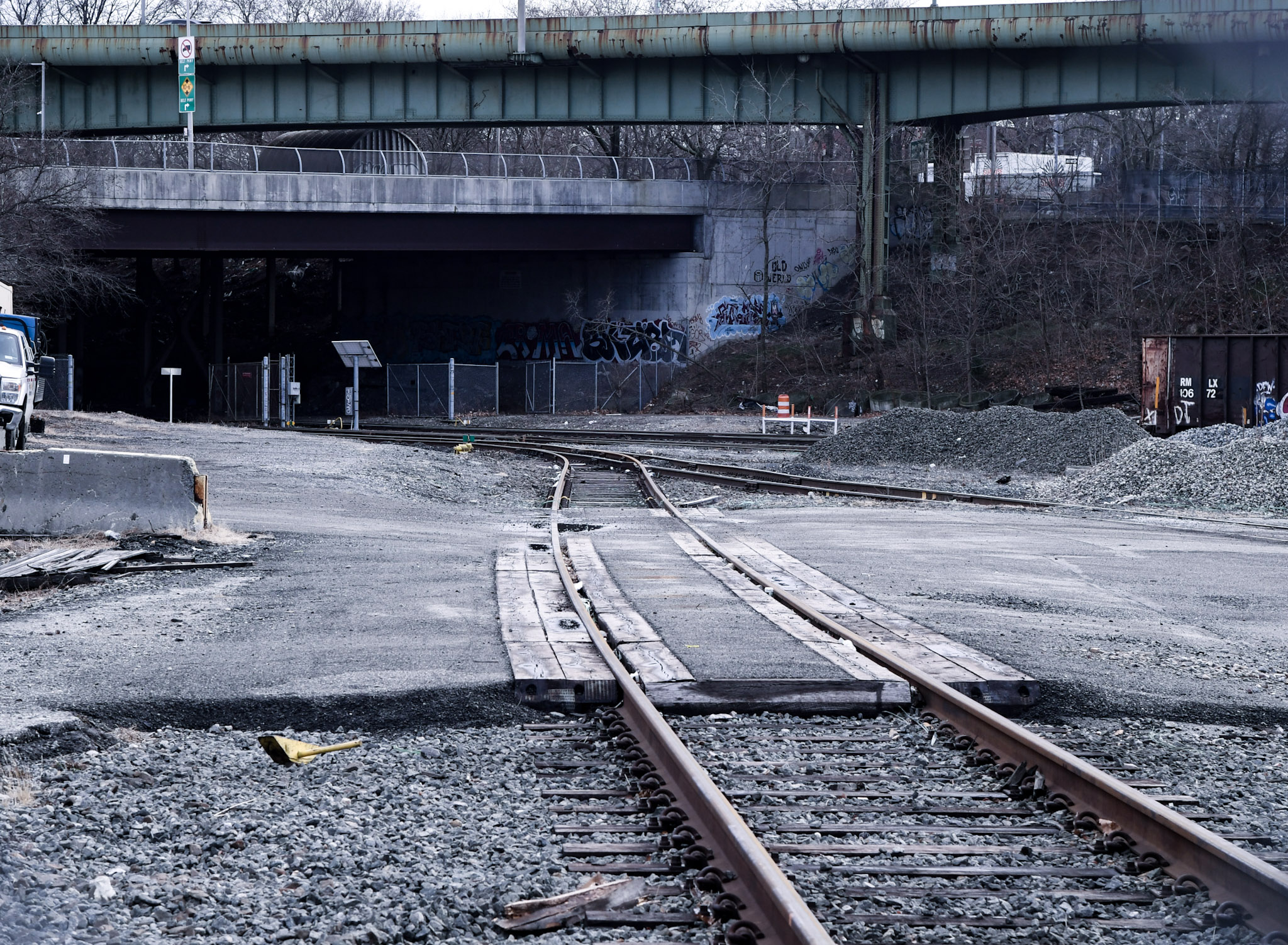
The MTA Corona Yard is familiar to tennis and baseball fans alike, but I always get a thrill from this view of the rolling stock of the 7 train. Dr. Eichenbaum briefly discussed transit and rail as we walked along, pointing out the critical nature that the opening of the subways played in the development of this section of Queens during the 20th century. In 1900, this area was famously a junk yard and known for the simmering piles of coal ash and cinders which were dumped here by the larger City.
From Wikipedia:
Corona Yard is the yard facility in Flushing, in the New York City borough of Queens, that serves the IRT Flushing Line (7) of the New York City Subway. It is located in Flushing Meadows-Corona Park, near Citi Field, the National Tennis Center, and the site of the 1939 and 1964 World’s Fairs.
Corona Yard opened in 1928 and has seen various models of cars, including Steinway Low-Vs, Brooklyn-Manhattan Transit Corporation/BMT Qs, R12s, R14s, R15s, World’s Fair R36s in 1964, and R62As. It also contains the Casey Stengel Bus Depot.
On August 16, 2006, the original 1928 shop building was demolished, and was replaced by a new, modern shop.

Our first stop was the Roosevelt Avenue Bridge, a span which carries pedestrian and vehicle traffic (and the elevated Subway tracks), over Flushing Creek. There did not seem to be any bike lanes, I would mention, which is odd given the proximity of the place to Citifield and the Flushing Meadows Corona Park complex of recreational and cultural institutions.
From nyc.gov:
The Roosevelt Avenue Bridge has been in service for more than 80 years since its completion in 1927. It is a 1,391 foot long, two-level, dual-use steel viaduct structure. On its lower level the bridge carries two lanes of vehicular traffic in each direction with an Annual Average Daily Traffic (AADT) of 20,000 vehicles per day over the Flushing River. An average of 26 pedestrians and 27 bicyclists utilize the bridge during the AM and PM peak hours. The upper level of the bridge supports the overhead NYC Transit’s elevated structure which carries the Flushing #7 line.

Dr. Jack Eichenbaum discussed the original state of Flushing Creek, describing spartina grass and a naturally fed wetland that flooded with the tides. During the construction of the Worlds Fair, the waterway was straightened and rerouted, which destroyed its ecology. It was further degraded by the action of Combined Sewer Outfalls, and has fallen victim to several invasive species of plants and animals since.

Backing down off the bridge, Dr. Eichenbaum led the group over to the so-called Iron Triangle. Until recently, this was a blue collar industrial district renowned for its multitudes of automobile repair shops. The powers that be have decided that there are more productive uses for this area, and accordingly, the full weight of municipal authority has been implemented around these parts.
From nycedc.com:
Land uses in the District primarily consist of auto-related services and industrial uses. Auto- related services are the most prevalent use in the District. These services consist of auto-body repair, auto glass, car washes and auto detailing, used and new auto part sales, tire sales, and vehicle towing. For the most part, these auto-related businesses occupy one-story garage buildings and Quonset-type structures, many of which contain multiple auto-related businesses. There are also a number of car junkyards in the District, which support auto salvage businesses.

The city goes out of its way to let the businesses located here know that they’re no longer welcome. There are no sewers, the DSNY does not plow away snow, the DOT does not repair pot holes. Eminent Domain powers have been invoked, and property seized. To be fair, the municipality has aided in the relocation of some of these businesses, but there are hard feelings all around. The area, nevertheless, has been designated for “Urban Renewal,” which is a term you don’t hear much these days.
Also from nycedc.com:
The Willets Point Urban Renewal Plan (URP) was adopted in 2008. The URP defined the boundaries of the District and the area to be redeveloped and established maximum square footage development envelopes, in accordance with the City’s redevelopment goals. The overall maximum permitted floor area in the District was defined as 8.94 million square feet of zoning floor area (zsf), with maximum permitted floor areas for residential and commercial uses (5,850,000 zsf of residential use, 3,160,000 zsf of commercial use). The URP, as well as the special district regulations, also requires the creation of a minimum of eight acres of open space in the District and a minimum 650-seat school.

Our group gathered the interest of several of the laborers from the surviving businesses, whose bosses have had their property rights vacated and now operate on short term leases with their new landlord – NYC – and a few of them began conversations with those of us who could speak Spanish. I’m not conversant in the language, so I can’t tell you what they were saying.
Heavily accented English, however, admonished and warned against trying to walk across the three to four inches of wet ice which coated the shattered pavement.

Auto parts, trash, and tires were embedded in the ice and snow – which had occasional breaks in it that hosted semi frozen ponds. Wet ice is particularly difficult to walk on, incidentally, and Dr. Eichenbaum wisely decided on an alteration in our route in the name of safety.

Shuttered and relocated businesses, at the corner of 39th Avenue and Willets Point Boulevard. Occasional vehicles tried to negotiate their way along, but they were slipping and sliding all over the place. It was sinking in how hazardous these streets are, and I was thinking about a friend of mine who died back here due to a hit and run.
An art director and photographer, my friend Ray August was a member of the Queensboro Motorcycle Club, whose clubhouse used to be back in the Iron Triangle during the early 1990s. I don’t know if they’re still out here, but I suspect that QBMC has moved on to greener pastures. Lost in my reverie about a lost friend, I was suddenly jolted out of my thoughts by a loud crash.

This SUV had crashed through the ice and become stuck in a hopeless position. It took a bit of rocking back and forth and a frantic spinning of its tires on the ice to draw out some of the laborers, who noticed the helpless driver and helped to push the vehicle back into a position where it could gain some traction.
From nycedc.com:
With mixed-income housing, retail and entertainment amenities, public open space, community facilities, a hotel, and a convention center, Willets Point will become New York City’s next great neighborhood.

Dr. Eichenbaum discussed the plans for Willets Point, and the complicated process which has led to plans for a mega development that will reshape the area. The city plans on installing sewers, and creating a safer environment hereabouts, incidentally. How it will all work out is something for the historians of the 21st century to decide, I guess.

The tour was just one of several events at the Queens Museum on Sunday, and Dr. Eichenbaum wound things up at Citifield. The new stadium is part of the urban renewal project, and it was an appropriate spot for him to hand the virtual baton over to the sponsor of the event, the 596 Acres organization. 596 Acres has a fascinating exhibition underway at Queens Museum’s Panorama of the City of New York display, which details the 155 Urban Renewal plans adopted by the City of New York over the years.
From 596acres.org:
596 Acres will present all 155+ urban renewal plans that the City has ever adopted in an intervention directly on the Panorama of the City of New York, realizing the online Urban Reviewer map on a 1:1200 scale of the 9,335 square foot Panorama.
New York City began to adopt “urban renewal plans” in 1949 to get federal funding to acquire land, relocate the people living there, demolish the structures and make way for new public and private development. The legacy of these neighborhood master plans remains active across the city, from sites like Lincoln Center to the many vacant lots cleared in East New York and Bushwick for projects that were never completed. Even after federal funding for the program was cut in 1974, New York City continued to adopt renewal plans for neighborhoods – 82 plan areas, where the city has eminent domain power to take private property for the public purpose of eliminating blight and economic “under-performance,” came into being between 1975 and the present.
Urban renewal transforms the city, and changes the lives of many New Yorkers, for better or worse. Over 60 plan for areas of the city remain active today. Some communities are taking advantage of active plan areas to make community aspirations into official plans.

Curating the event, and supplying copious amounts of hot chocolate (and hand warmers) to the walking tour group, is Paula Z. Segal. You may recognize her from my post on LIC’s Smiling Hogshead Ranch. Ms. Segal welcomed the group to accompany her back to the museum, where a full afternoon of activities were planned.
From 596acres.org:
We support groups creating community land access tools in their own cities through open source code and hands-on mentorships. We are also the convener of an international Community Land Access Advocacy network that will have its first in-person meeting this spring: save the date for Turning Our Vacant Acres into Community Resources on April 22 & 23, 2014, at the New School in New York City.
In New York City we are community land access advocates and use one of our tools. Our NYC Land Community Access Program started in Brooklyn in May 2011. Click for a PDF version of our 2011-2012 Recap and these incredible impacts in 2013! There are now 22 new spaces in New York with official permission to transform public vacant lots into something better.

As for myself, the 7 train was running, and I needed to get back to Astoria and the warmth of HQ. What? You think the dog is going to walk herself?
As a note, I have not attended a single game at Citifield yet. Went to Shea to watch the Mets lose a bunch of times, but for some reason, I’ve still not seen them lose a game at Citifield.
Newtown Creek Alliance Historian Mitch Waxman lives in Astoria and blogs at Newtown Pentacle.
What a wonderful, wonderful post Mitch – thank you! 🙂