
Updated Hurricane Evacuation Map Shows Much of Southern Brooklyn in High-Risk Zones
The city released updated hurricane evacuation zones on Tuesday, just as what meteorologists predict will be a busier-than-normal Atlantic hurricane season begins.

A home damaged by hurricane Sandy in Seagate. Photo via REUTERS/Lucas Jackson
The city released updated hurricane evacuation zones on Tuesday, just as what meteorologists predict will be a busier-than-normal Atlantic hurricane season begins.
The new zones can be viewed on a map released by the city’s Emergency Management Department. New Yorkers can input their address into a search bar to see what zone they live in, if they live in one at all. The zones have been updated to incorporate new data and “information from actual events,” in order to identify flood risks on a more granular, community level.
Overall, about 3.1 million New Yorkers live in one of six evacuation zones, the department said, and about a million live in a different zone than last year. Those New Yorkers living in these areas could be ordered to evacuate if forecasters predict a strong hurricane headed to the city.
“New Yorkers have been through extraordinary challenges in the past year. Now, it’s on all of us to make sure we’re ready for the next emergency ― and that means having a plan for hurricane season,” said Mayor Bill de Blasio in a statement. “Knowing your evacuation zone, preparing for flooding, and checking in on your neighbors and the elderly are easy steps that will make a difference when it matters most. Together, let’s stay safe this season and build a recovery for all of us.”
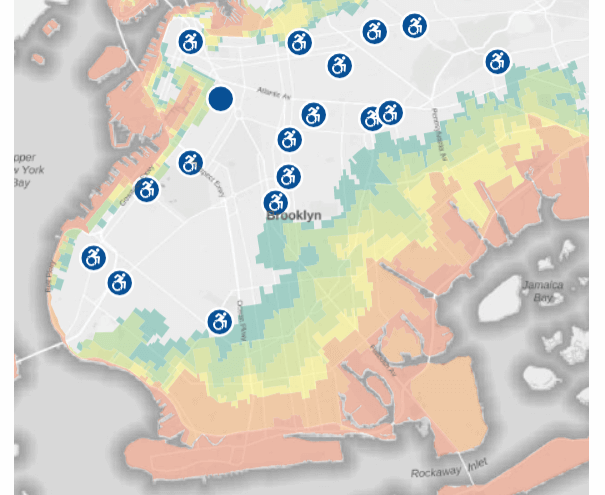
Coastal, low-lying southern Brooklyn neighborhoods are particularly vulnerable to a storm surge, as was seen during Superstorm Sandy in 2012, and large swaths of the area are within the two most vulnerable zones. Zones 1 and 2 include all of Coney Island, Brighton Beach, Manhattan Beach, Gerritsen Beach, Mill Basin and Bergen Beach, and large sections of Gravesend, Sheepshead Bay, Marine Park, Canarsie and East New York.
As for southern Brooklyn’s green space, Marine Park, Floyd Bennett Field and Shirley Chisholm State Park are all situated in Zones 1 and 2, as are other coastal parks.
Elsewhere in the borough, neighborhoods perched largely in the highest risk zones include Red Hook, Greenpoint, East Williamsburg and the Brooklyn Navy Yard area. Waterfront areas all along the East River, from Greenpoint to Bay Ridge, are also in those zones.
The map includes guidance advising New Yorkers in evacuation zones to take up shelter in the home of friends or family outside the zones if ordered to leave, but also shows various public evacuation shelters, mostly school buildings.
The city is also relaunching its “Know Your Zone” public outreach campaign, aimed at informing New Yorkers about their evacuation zone status and encouraging people to make contingency plans.
The National Oceanic and Atmospheric Administration predicts a 60 percent chance that this year’s Atlantic hurricane season will be busier than average. NOAA’s forecast projects a “likely range” of 13 to 20 named storms, where winds are 39 mph or above. That includes six to 10 predicted hurricanes with winds at or above 74 mph, and three to five major hurricanes, with winds of 111 mph or above. NOAA’s statistics posit that an average season includes 14 named storms, seven hurricanes, and three major hurricanes.
The Atlantic hurricane season lasts from June 1 until November 30.
Editor’s note: A version of this story originally ran in Brooklyn Paper. Click here to see the original story.
Related Stories
- Rezoning Proposed for Southern Brooklyn’s Flood-Prone Coastal Neighborhoods
- Brooklyn Floods, Loses Power in Hurricane Sandy
- Hurricane Irene’s Aftermath, in Photos
Email tips@brownstoner.com with further comments, questions or tips. Follow Brownstoner on Twitter and Instagram, and like us on Facebook.
What's Your Take? Leave a Comment