
Past and Present: The BQE at Washington and Park
A Look at Brooklyn, then and now. Robert Moses had proposed a highway connecting Brooklyn, Queens and the Bronx, as early as the mid-1930’s. Unlike some of his other parkways, the BQE was always designed to hold both commercial and non-commercial traffic, and was as much a vehicle for inter-borough commercial traffic as it was…

A Look at Brooklyn, then and now.
Robert Moses had proposed a highway connecting Brooklyn, Queens and the Bronx, as early as the mid-1930’s. Unlike some of his other parkways, the BQE was always designed to hold both commercial and non-commercial traffic, and was as much a vehicle for inter-borough commercial traffic as it was supposed to be a great connector of boroughs for the public.
In 1939, Brooklynites were able to cross the brand new Triborough Bridge, and motor to the 1939-40 World’s Fair in Flushing Meadow, Queens. By the 1940, Moses planned linking the Kosciuszko Bridge crossing to the Williamsburg and Manhattan Bridges, extending the BQE through the neighborhood of Williamsburg and Greenpoint. World War II put that idea on hold, and it wasn’t until 1946 that the project was continued in earnest, until its completion, in 1960.
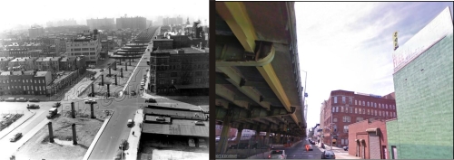
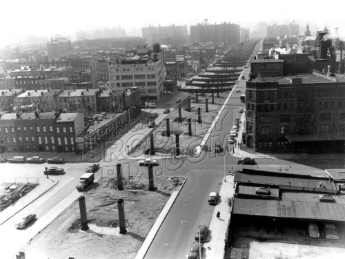
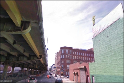
We all know the stories about the creation of the Promenade and the bisection of Red Hook, but little is ever written or said about the part of the BQE that runs a block away from the Navy Yard. This section was the last leg of the highway to be finished, and was completed in 1960. The Brooklyn Pix photo, taken in 1959, shows the pylons and supports for the elevated highway being laid, the work extending towards Downtown Brooklyn and the horizon.
Park Avenue is so airy and bright in 1959, a phenomenon we’re not likely to see again anytime soon. Aside from that, not all that much has changed in the vicinity. The former Van Glahn Warehouse/Rockwood Chocolate factory building is on the right side of the photo, in the center. Across the street, and up a block, on the left, rises the Drake’s Cakes Bakery. Today, that building is the Benjamin Banneker Charter School, and the Rockwood factory is now lofts and apartments. GMAP


A highway connecting the boros was obviously a necessity, the alternative would be trucks carrying their goods through city streets.
It is unfortunate that the ideal at the time the BQE was planned was to build these elevated highways as if the land beneath was a marsh teaming with hungry crocodiles. It was an unfortunate era and Moses really just reflected the thinking of the best and brightest of the day.
The BQE like the old elevated Westside Highway was a road over another road. Those of us older than Justin Bieber remember the demo of the Westside Highway (what a mess that was for a while) and hope we will live to see the demo of this monstrosity.
There has to be a better way to deal with ground transportation than lifting it twenty feet into the air on massive rusting pylons.