
Design Phase Nears Halfway Mark on Red Hook Coastal Resiliency Project
On the heels of major flooding from Hurricane Ida, residents of low-lying Red Hook met with city design heads about an ongoing storm-proofing plan for the waterfront neighborhood.

A woman makes her way through flood waters in Red Hook during Hurricane Sandy. Photo by REUTERS/Keith Bedford
On the heels of major flooding from Hurricane Ida, residents of low-lying Red Hook met with city design heads about an ongoing storm-proofing plan for the waterfront neighborhood.
Mayor de Blasio commissioned the Red Hook Coastal Resiliency Project in 2015 after then-mayor Michael Bloomberg recommended the idea in 2013 in the wake of Superstorm Sandy — when floodwaters rushed into the neighborhood from all sides, inundating some parts of the area with up to eight feet of water, which knocked out power for weeks and destroyed homes and businesses.
Red Hook presents a particular challenge for flood protection measures, as many of the buildings in the low-lying neighborhood are old and some are home to expensive, hard to move industrial equipment.
“These conditions make site-specific flood protection measures a challenge, likely leaving many residents, businesses, and infrastructure assets exposed,” a 2013 report says. “Subject to available funding, the City, therefore, will install an integrated flood protection system in Red Hook, composed of permanent features, temporary features, and landscaping and drainage improvements.”
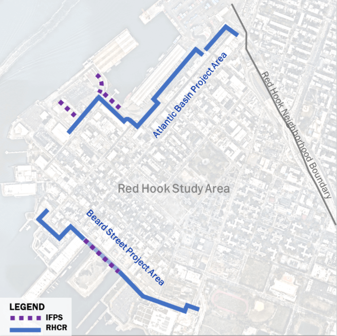
Map via Department of Design and Construction
That funding for the collective came in spring 2015, when Mayor de Blasio announced OneNYC, which included $20 billion for resiliency projects across the city.
The project focuses on the Atlantic Basin and Beard Street — two areas identified by the city as being particularly vulnerable to sea level rise and storm surge. Earlier this year, the city finished installing temporary flood protection at the Atlantic Basin — semi-permanent barriers that are left open day-to-day and closed during storms to protect the surrounding area from storm surges.
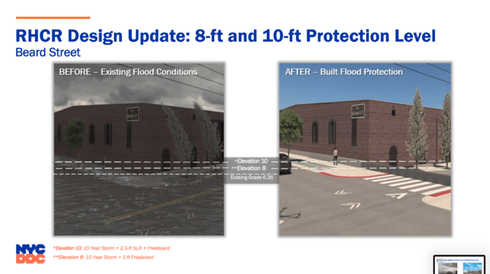
As the city’s Department of Design and Construction have worked to design the permanent flood protection infrastructure, they have incorporated notes and feedback from the community regarding the interim measures, said Joseph Menzer, an engineer with the city’s Department of design and Construction, at Wednesday’s meeting. The interim flood protections can hold back floodwaters at up to eight feet above sea level, where the permanent measures, when implemented, will hold back water at up to 10 feet above sea level.
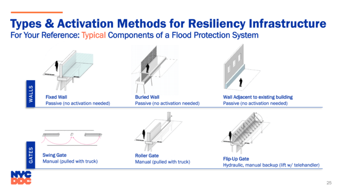
Those permanent measures will include “passive” measures, which will be in place at all times — flood walls and street raising. These passive measures will be able to hold back water at up to eight feet. The plan also includes deployable rolling or lifting gates, which will be activated ahead of hurricanes or storms expected to rise to 10 feet.
“The interesting thing about these features is that they are permanent, they are installed within Red Hook”, said DDC engineer Joe Menzer. “And they get put into place very quickly, they aren’t stored in a warehouse and need to be brought to site ahead of a storm event and then returned to site. They can be deployed very quickly and then returned to their undeployed state very quickly after a storm has passed.”
As of October 2021, design work is 30 percent completed. DDC estimates that designs will be finalized in 2023, and construction will begin in early 2024.
“After that late 2023 final design is submitted, it goes to FEMA for their review and approval,” said Kiumars Amiri, a deputy director of community engagement with the DDC. “That’s when we initiate our procurement process. Procurements, particularly for these large infrastructure projects, can take several months.”
During the procurement process, contractors will submit bids and the city will review them and choose one, Amiri said, and then has to onboard the winning contractor.
“For community purposes, day one of construction has a different definition than day one of construction for our purposes,” Amiri said. “There’s a lot of leg work that happens before contractors show up with fences and trucks and equipment.”
Construction is expected to take about two years — wrapping up in late 2026.
Early next year, the Public Design Commission will review the current plans, and will do so again when designs are finalized. DDC must also submit each plans to FEMA and CB6 at each stage. Questions and concerns can be sent to rhcr@ddc.nyc.gov.Questions and concerns can be sent to rhcr@ddc.nyc.gov.
“Right now, we’re wrapping up the existing conditions of environmental analysis,” Amiri said. “Soon after that, we’ll start the next steps of the environmental analysis. We don’t have any details on that, I know a lot of folks are really interested and anxious to hear more about that. At this point, we’re not really anticipating significant impacts as a result, but, again, these details haven’t really been developed yet.”
The potential impacts will become more clear when the project design reaches 60 percent completion, he said, and the department has a better idea of what they will be constructing.
In prior meetings, the community has expressed concerns about maintaining waterfront access and green space, Amiri said, and the department is keeping that in mind as they continue work.
“One of the other nice things about this flood protection system that you should be aware of is that we are able to build out big portions of the Brooklyn Waterfront Greenway along with it,” Menzer said. “We are going to be incorporating that into the portions along Clinton Wharf, Ferry Street, and Beard Street.”
This year, Amiri said, the department has met with elected officials including Council Member Carlos Menchaca and Assemblywoman Marcela Mitanyes, as well as companies in the neighborhood including Ikea, UPS and Amazon. Community groups, like Resilient Red Hook, have also been part of design meetings – as has the New York City Housing Authority.
Red Hook Houses were hit hard by Sandy and waited years for needed repairs and relief — and residents have raised concerns about hundreds of trees removed from the complex as part of NYCHA’s Recovery and Resiliency Capital Project, a separate endeavor from the DDC’s Red Hook coastal resiliency project. Amiri emphasized the separation between the two projects.
“Both projects, the goal and mission of both projects, is, obviously, resiliency upgrades, and improving conditions in the neighborhood,” he said. “But the NYCHA project is being specifically managed and constructed by NYCHA, within the grounds of NYCHA, and our project is outside of NYCHA property within the larger neighborhood.”
Menzer said the 10-foot protections are in line with the city’s projections for the most frequent storms up to 2050 and into the 2100’s.
“We want to make sure that when we’re protecting Red Hook, it’s not just for today, it’s for families to be protected well into the future.”
DDC will visit the community board again as design work continues and is finalized next year and in 2023.
Editor’s note: A version of this story originally ran in Brooklyn Paper. Click here to see the original story.
Related Stories
- Locals Fear Health Risks After Suspected Oil Spill During Construction of Coney Island Ferry Landing
- Rainfall-Absorbing Green Roofs Installed at the Brooklyn Navy Yard
- New York Requests Proposals for Flood Protection in Red Hook
Email tips@brownstoner.com with further comments, questions or tips. Follow Brownstoner on Twitter and Instagram, and like us on Facebook.
What's Your Take? Leave a Comment