
Past and Present: The House at Nostrand and Parkside
A look at Brooklyn, then and now. New York City is, by and large, built on the ruins of its past. If left to the powerful real estate concerns of this city, there probably would only be a handful of old buildings around, the iconic masterpieces, and everything else would periodically be razed in order…

A look at Brooklyn, then and now.
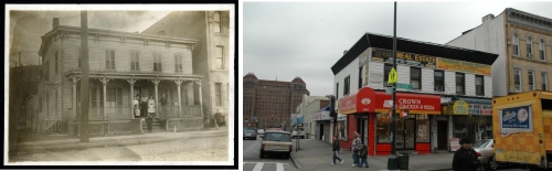
New York City is, by and large, built on the ruins of its past. If left to the powerful real estate concerns of this city, there probably would only be a handful of old buildings around, the iconic masterpieces, and everything else would periodically be razed in order to build anew. The city has been like that since the Dutch landed. New Yorkers like new, newer, newest. Brooklyn is a little different; her history always more residential and tied to the land, but even here, the progression from Dutch farmhouse, to wood framed buildings, to masonry structures, to modern glass and steel can be found in just about every neighborhood. So with that in mind, when I saw the photograph of the wood framed house, with a family on the porch, I was quite certain this house was long gone. I was very wrong.
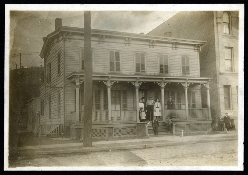
First of all, it is rare to have an address to work with. Many of the photographs in the collections of the Brooklyn Public Library, Brooklyn Historical Society and Brooklyn Museum are unmarked, and their locations unknown, unless there is a very recognizable landmark in the photo. But this one came to the Brooklyn Museum with an address, the corner of Parkside and Nostrand Avenues, in Flatbush. Today, we’d consider this the outer reaches of Prospect Lefferts Gardens, or perhaps Wingate. The photograph itself gives us some clues as to the general year it was taken, and when you go to the maps, which I love to do, the mysteries begin to unravel.
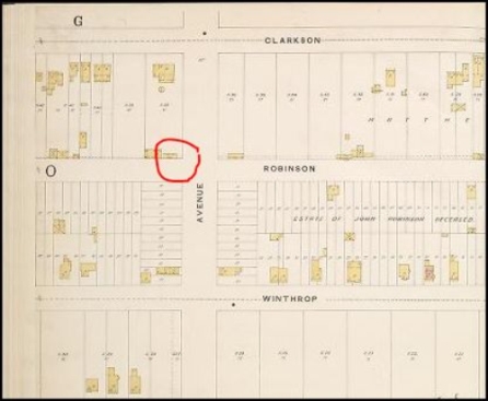
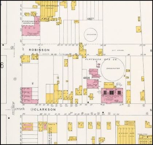
This part of Flatbush was farm country up until the last decades of the 19th century. The street grid had been laid, but by 1888, development was not rapid. The maps show wood framed structures here and there on the blocks, with many plots still empty of buildings. Parkside Avenue was named Robinson Street at that time, the name was not changed until the 20th century. The vantage point of the 1888 map is reversed from most other maps, with Clarkson on the top, but it clearly shows a wood framed building on this corner. Was it this house? I don’t think so, the icon is much too small, but it may have been the forerunner of this house. Perhaps, like many houses, built in stages.
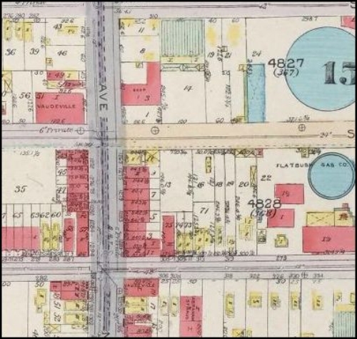
So then I go the 1898-99 map, one of my favorites for tracking city building, but Flatbush is not included in the map. How disappointing. The next map available is from 1905. This is very interesting, because some of the photograph’s other clues are here. By 1905, this part of Flatbush had been given over to a lot of industry and large institutions, but this house is here in the size shown in the photo. The old Almshouse was becoming Kings County Hospital, and in the background of the photo, on the left, can be seen a huge tank. This was the larger of the “gasometers,” the storage tanks for the coal-derived gas used for lighting and heating. They can be seen on the map, part of a huge facility for the Flatbush Gas Company, which also seems to have closed off the street, with a wooden structure, a gatehouse probably, that prevented people from entering the plant.
So when was the photo taken? The clothing would suggest sometime between 1905 and World War I. The woman’s hat and suit would be in fashion during that time. The photo had to have been taken after 1905, but before 1916, because we don’t see the flats buildings next door on the 1905 map, they were built afterwards, but don’t look brand new in the photo, so I’m going to say the photo dates from about 1910 or 1912. By 1916, when the last map was drawn up, the gasometer tank is still there, as are the flats buildings, as well as a theater and other amenities of a growing neighborhood.
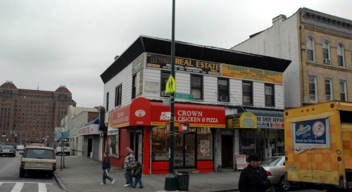
Today, that neighborhood is much changed. The Flatbush Gas Company and its tanks are long gone, replaced by electricity, probably soon after the 1916 maps were drawn up. That block became home to small businesses, garages and later, parking lots. This entire neighborhood began to go into a slow decline, trapped between Kings County Hospital and the apartment building and row house rows of Prospect Lefferts Gardens. But this house survived! Amazing. In the late 20th century, it’s been a pizza place, a bakery, and now a fast food chicken place, and a shoe repair shop, with a day care center and another office upstairs. The rooms that made this house a home to the family in the photo have long been torn out, the porch long ago removed, and the roof’s brackets enclosed in aluminum siding. Nothing original remains except for the frame. Yet the building is still standing, a truly forgotten piece of Brooklyn’s past. GMAP
1888 map, New York Public Library


What's Your Take? Leave a Comment