
The Changing Faces of Red Hook, as Seen in Maps From 1770 to the Present
By Suzanne Spellen (aka Montrose Morris) Live in Brooklyn long enough, and you’ll be used to change. Shops, restaurants, and bars come and go, warehouses become condos, whole blocks are transformed as high-rises replace three-story buildings. None of us, however, have lived in Brooklyn long enough to see how much the shore line itself has changed….

By Suzanne Spellen (aka Montrose Morris)
Live in Brooklyn long enough, and you’ll be used to change. Shops, restaurants, and bars come and go, warehouses become condos, whole blocks are transformed as high-rises replace three-story buildings.
None of us, however, have lived in Brooklyn long enough to see how much the shore line itself has changed. For that, we need to go much further back.
By looking at almost 250 years of Brooklyn maps, we can watch the entire shape of Red Hook morph as it evolves from marshlands to docklands and beyond. The first stop on our time machine will be 1770.
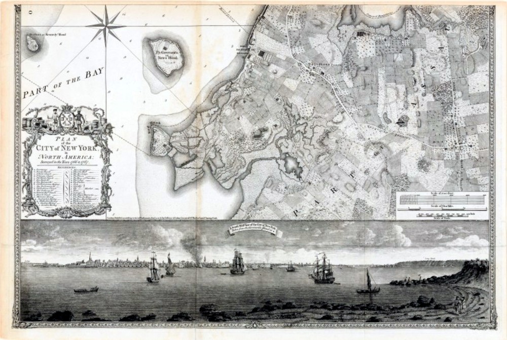
The Ratzer Map of New York City
This map from 1770 is a New York treasure. It’s called the “Plan of the City of New York,” executed beautifully by Bernard Ratzer, a British army officer, surveyor and cartographer.
Although there are maps of the area that are earlier, Ratzer’s map is the most detailed and the most beautiful. There are only four known copies of it in the world. One belonged to King George, and is in the British Museum, and two more belong to the New York Historical Society in Manhattan.
A fourth was recently re-discovered in the warehouse of the Brooklyn Historical Society in 2011. It is believed to have been given to the Society by someone in the Pierrepont family, although the records have not yet been found of that transaction.
The map was printed on paper which was then mounted on linen. It had been shellacked to protect it, but the shellac had yellowed and cracked the paper badly. The map had also been cut in strips and the entire thing rolled up.
A paper restorer named Jonathan P. Derow painstakingly restored the map, and it is on display at the Brooklyn Historical Society. This New York Times article explains the discovery and restoration.
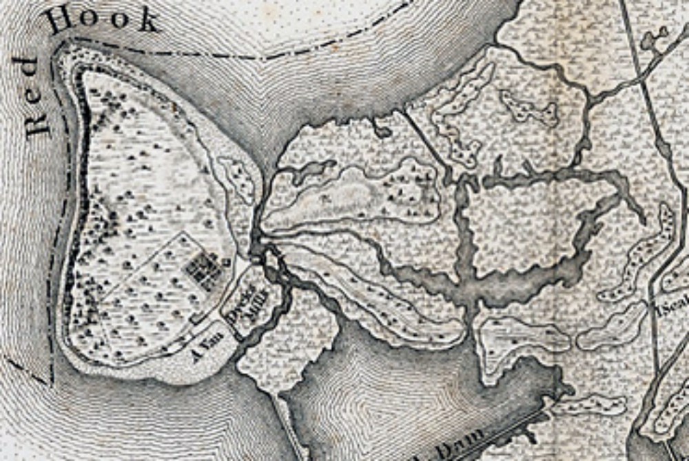
The map shows in great detail the settled part of Brooklyn at the time – the town of Brooklyn across the river from Manhattan, and South Brooklyn and Gowanus, on east to Bedford, as well as a wonderfully detailed look at Red Hook.
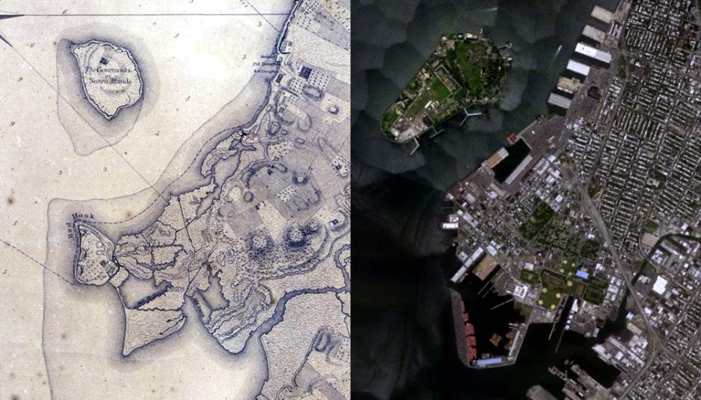
The map shows orchards and farms, and a marshy coast, dotted with ponds, streams and inlets. The shoreline is very different than the one we know today. You can check out some of the previous articles in this series to learn about how Red Hook’s coast was altered, first by the Dutch and then by the 19th century shipping magnate William Beard.
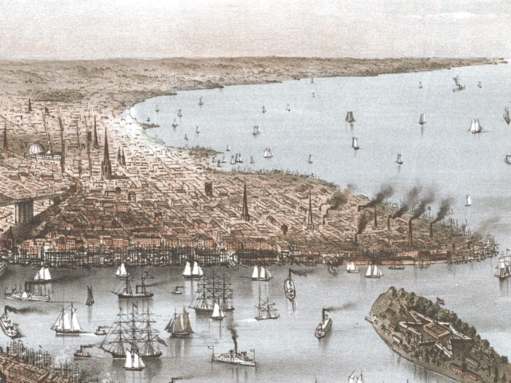
Lt. Ratzer also provided a beautiful illustration of Manhattan from Governor’s Island.
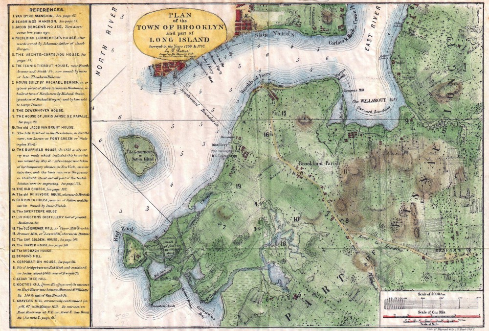
The Ratzer map was reproduced in the 19th century for a Brooklyn audience, for historian and author Henry Stiles. The Brooklyn part of it was enlarged, colored, and printed with a legend.
The map shows the location of the homes of prominent early Brooklynites such as the Bergen, Cowenhoven, and Rapelje families, as well as well-known local landmarks.
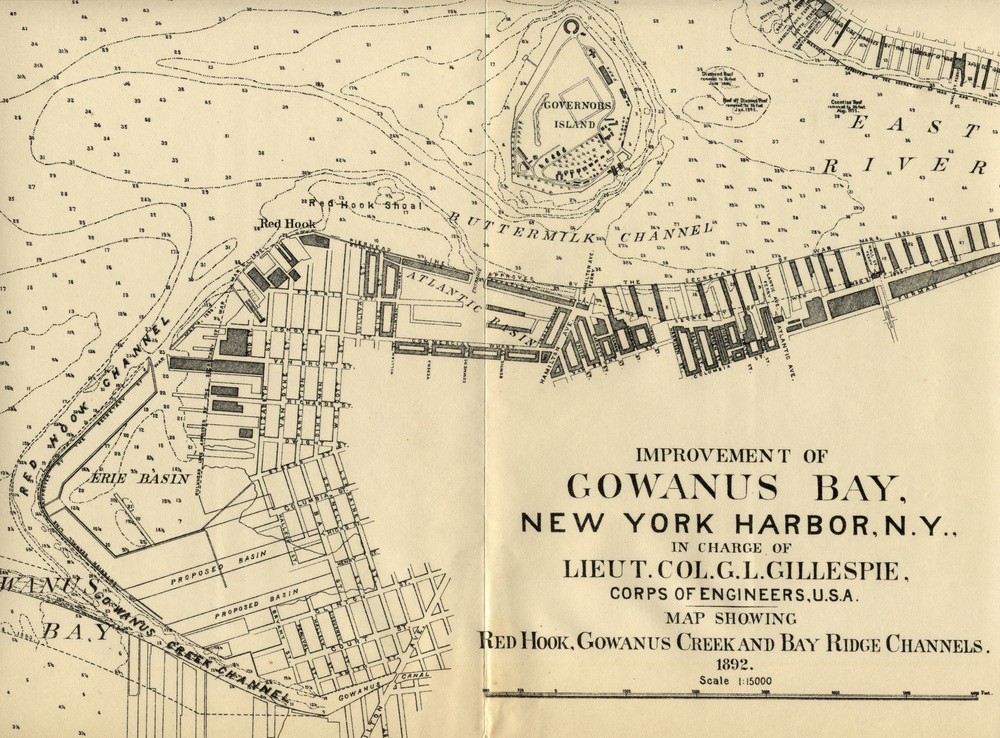
1892 Corps of Engineers Map
Navigating the waters around Red Hook wasn’t easy. Ships approaching the Red Hook docks through the Buttermilk Channel had to avoid various shoals — hazardous ridges or sandbars that lay just below the surface.
Beginning with an initial survey of the Buttermilk Channel in 1872, the United States Army Corps of Engineers (CoE) embarked on a series of projects that would make navigation safer from Bay Ridge to the East River. Between 1880 and 1899, the CoE dug out the Red Hook and Buttermilk Shoals, dredged out the Bay Ridge and Red Hook Channels to make the sea lanes much wider and deeper, and did the same for the Gowanus Canal. Not suprisingly, the aforementioned Red Hook shipping magnate William Beard owned a dredging company that was contracted to do much of this work.
Looking at the 1892 map above, you can see the work in progress, including the depths of the waters around Red Hook and proposed basins that would further change the shape of Red Hook’s shoreline.
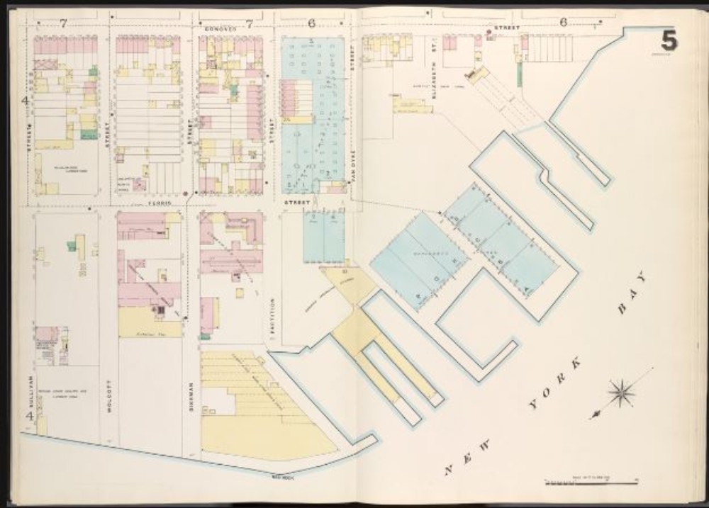
Sanborn and Other Insurance Maps
The 19th century also saw the printing of very accurate and detailed fire insurance maps. Each block in the city was carefully delineated, showing each building. Many of the larger civic and cultural buildings are labeled, as are the buildings belonging to large or important companies.
The best of these atlas maps were printed by the Sanborn Company, although other companies also printed their own insurance maps. A city the size of Brooklyn took up as many as six volumes to cover, part of the reason they weren’t printed every year. Sanborn is still publishing insurance maps.
The maps for the Red Hook area are fascinating, as they reveal all of the businesses that flourished along the river front. Many of the warehouses, factories, coal yards, grain sheds, sugar refineries, chemical plants and tobacco companies, to name only a few, are listed.
The maps also color code the buildings. Yellow is wood-framed, pink is masonry and blue is concrete block. Perusing these maps and noting the changes over the years, as well as the locations of industries and buildings long gone is a fascinating pastime. Above is the 1886 map showing part of the Red Hook shoreline.
Other Maps
There are, of course, many other maps that feature Red Hook. The advent of photography, specifically aerial photography, gives us new images of entire neighborhoods, as well. New maps from Google Earth, Property Shark and other on-line sources can now map out every street with great detail. They are all invaluable resources to finding both the past and present.
Most historical bloggers are fascinated by maps. One of these, Conner Eugene Gaudet, writing for the Red Hook Star Review provides one of the most interesting of period maps.
He superimposed an 1874 map of Red Hook on top of a present day map. It clearly shows the activity in the area since the Revolutionary War. All of Red Hook’s history is here.
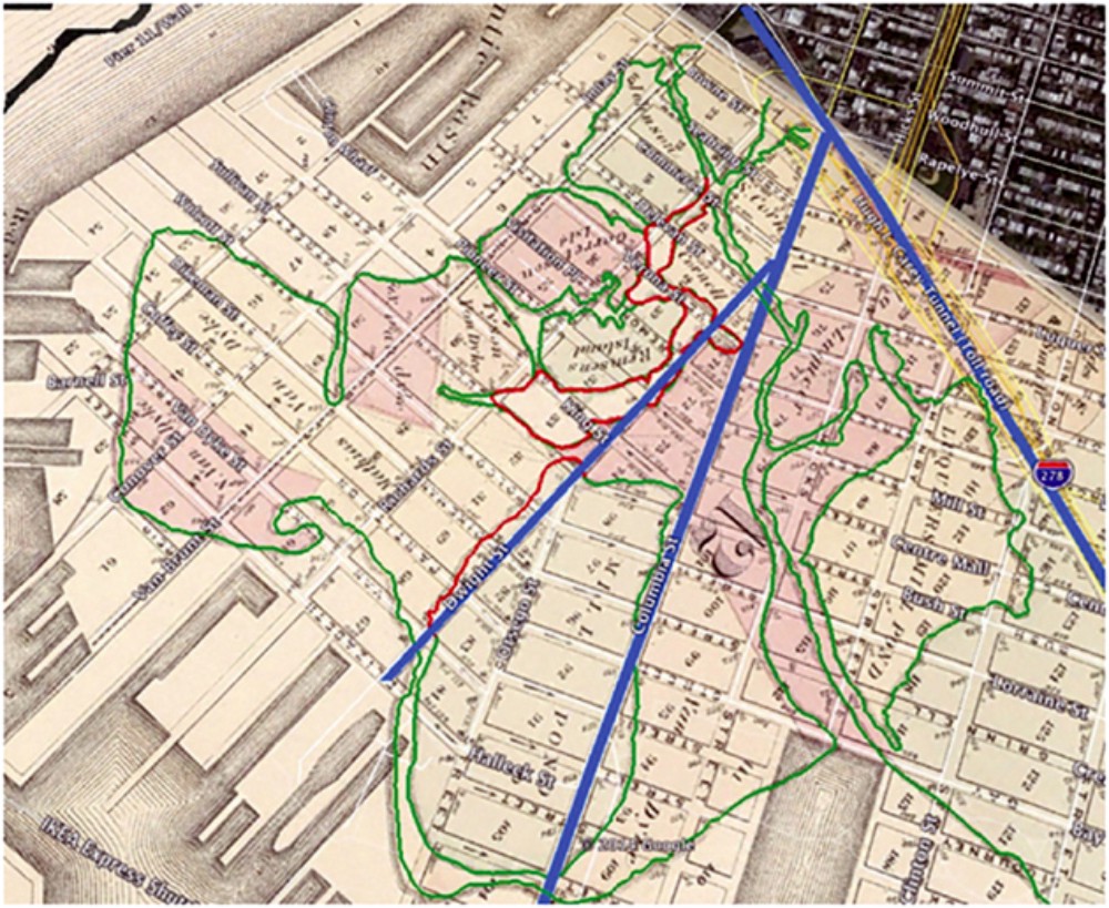
We can see where Ratzer’s ponds, streams and marshes were filled in. We see the landfill that expanded the shoreline, creating more land for the Atlantic and Erie Basins, a lot of land, actually. We see the remaining piers that were built out into the harbor, and see how the street grid was established on what was once farm land, orchards and swamps.
Related Stories
How Red Hook and Buttermilk Channel Got Their Names
The History of King Cotton and the Red Hook Stores
How Red Hook’s Fort Defiance Changed the Revolutionary War
Walkabout: The German American Stores Fire in Red Hook


Comments