
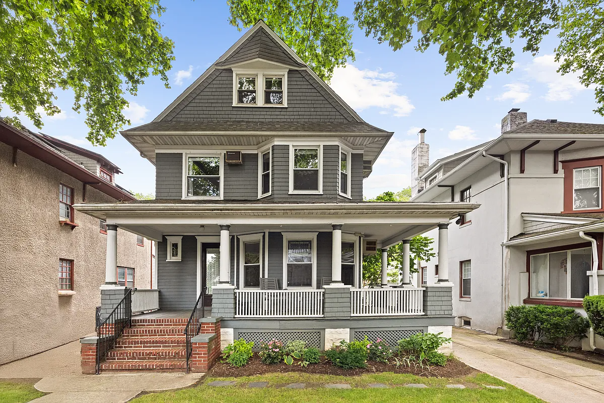
House of the Day: 7543 Shore Road
Some folks got a little grumpy a couple of weeks ago when we poked some fun at a McMansion in Bay Ridge, saying we should have focused on some of the beautiful architecture in the area (and there’s plenty). Today’s House of the Day at 7543 Shore Road isn’t the finest example in the nabe,…

Some folks got a little grumpy a couple of weeks ago when we poked some fun at a McMansion in Bay Ridge, saying we should have focused on some of the beautiful architecture in the area (and there’s plenty). Today’s House of the Day at 7543 Shore Road isn’t the finest example in the nabe, but it’s got a nice feel to it, plus it’s gigantic and has water views. It ain’t cheap though! $4,200,000. Hmmmm.
7543 Shore Road [Corcoran] GMAP P*Shark
Benson, Thanks, I too share an admiration for Moses in a broad context, but do recognize how & why many long gone Brooklynites , including those in my own family despised him. Moses was a member of “Our Crowd” and his generation and class and has to be taken in that context. As he grew older he was easier to hate and his eccentricities only fueled these fires. As you may know , he never drove a car . Moses was truly a cursed figure in much of 1950’s Brooklyn but in reality his eminent domain practices of that era were for the most part an abomination.
Crescent Hill;
I haven’t had a chance to introduce myself before, but let me just say that your substantive posts are a welcome addition to Brownstoner.
On the issue of the Belt parkway/Shore Road: I am big Robert Moses fan, and think that – given the situation at the time – he did wonders for the city. Having said that, it is my belief that the best long-term improvement that could be made to Brooklyn is to suppress the Belt Parkway, and open up its beautiful waterfront again.
I think that Jamaica Bay, for instance, has enormous potential, if, once again, the Belt were to be supporessed. Well, we can dream, can’t we?
BTW, I am jealous that you have harbor views. I currently live in a condo in Park Slope, but am giving serious consideration to moving to one on Shore Road.
I think I’m a closet ship-spotter nerd. I really should buy a place with water views.
I have not , but I am familiar with the home, it’s history and it’s well preserved grounds thanks to some great info found on the website Forgotten NY. That SI property has an incredible view of the bay. From my vantage point/my home, I see many container vessels on a daily basis as they pass or are tugged into Upper NY Bay toward the ports of NJ in most cases. I face Anchor Bay, which is in upper NY bay. Many ships wait around at this spot, hence Anchor bay. In all honesty ditto, I don’t even look at the cargo ships anymore, but appreciate the sight of a daytime sail boat or nightlighted cruiseship much more. Granted, some of those container ships are actually larger than the smaller cruise line vessels that use the waterway.
Crescent Hill – have you ever been to the Alice Austen house on Staten Island. Its a beautiful old place with a peaceful large garden that spreads down to the water. Lovely views of the harbor, and you really get an incredible perspective on the huge size of the container ships as they slide in and out of the harbor there.
“The idea that construction of the Belt somehow blighted this waterfront is ridiculous”
I presume thats tongue-in-cheek.
Posted by: dittoburg at September 18, 2009 10:08 AM
Thanks Dittoburg, I do too.
The land that the Belt Parkway and the Shore Road Promenade sit on is landfill. Trucked and Tugged in by the much despised Robert Moses and his wrecking crews in the late 1930′ and early 1940’s. The development of a three lane highway with an adjacent “man made” promenade and roadside forever changed the landcsape of the old Shore Road. Before the Belt Pkway- Shore Road was the original Promenade of Bay Ridge. When the automobile first became popular much of the road was paved and then widened at carefully chosen points to create the graceful curves that we still see today on it’s length. One or two old dutch houses were sacrificed, even back then, to allow the road to become one of the most popular “motor car” destinations in all of the then newly formed 5 borough City of New York. As you may know Brooklyn was its own city until 1898 and it was after that merger that much of the road began to be updated and ” modernized”. The Bay water was much closer to the road and until the late 30’s it was accessible at many points to the actual shore/beachline. Small piers/ some with ferry service dotted it’s length and earlier large piling supported boathouses were on the road. All this may seem like ancient history now, however it is worthwhile to note. I have seen old photographs that are Pre-Belt Parkway and they support the fact that Automobile worshiping City planning forever changed the Old Shore Road.
Ok, well I’m sure Robert Moses would agree with you, but GMAP to the max and you’ll see 75 ft wide strip of concrete of which 20ft is usable by the people who want to take advantage of the waterfront and the remainder is just a 5-lane cut through for traffic which is of no beauty or benefit to any but those driving on it. (Which includes me sometimes).
Your basing your view on how it came into being. But the expressway is still a blight on the waterfront, and you only have to consider for a second what the waterfront would be without the expressway to see how negatively it affects it.
Not at all tongue in cheek. This public waterfront parkland was built as a component of the Belt Parkway project, and would not otherwise exist. The Belt didn’t blight this waterfront, it created it. No doubt the tidal mud flats that were landfilled to create the roadway and parkland had environmental value, but in terms of human access to and use of the waterfront, this project was a big plus.
“The idea that construction of the Belt somehow blighted this waterfront is ridiculous”
I presume thats tongue-in-cheek.