
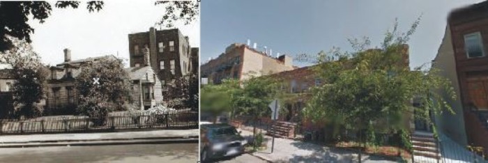
Past and Present: The Old Dutch House on Bainbridge Street in Bed Stuy
A look at Brooklyn, then and now. Since wooden houses are in the Brownstoner news lately, today’s Past and Present shows some that are no more. They were lovely little frame houses on Bainbridge Street, between Malcolm X Boulevard (formerly Reid Avenue) and Sumner Avenue. These houses were from this eastern part of Bedford’s early…
A look at Brooklyn, then and now.
Since wooden houses are in the Brownstoner news lately, today’s Past and Present shows some that are no more. They were lovely little frame houses on Bainbridge Street, between Malcolm X Boulevard (formerly Reid Avenue) and Sumner Avenue. These houses were from this eastern part of Bedford’s early development, back when the neighborhood’s streets were sparsely developed, and mostly had small groups of frame houses on rather odd shaped lots.
The lots are the legacy of the Dutch families who owned this land beginning in the late 1600s. By the beginning of the 19th century, most of the land that makes up Bedford belonged to the Lefferts family and their relatives by birth or marriage. It didn’t take clairvoyance for them to see that urban development was in the future, and when the city incorporated in 1834, and began planning outward expansion from downtown, the family began parceling off their land, and selling to developers and individuals.
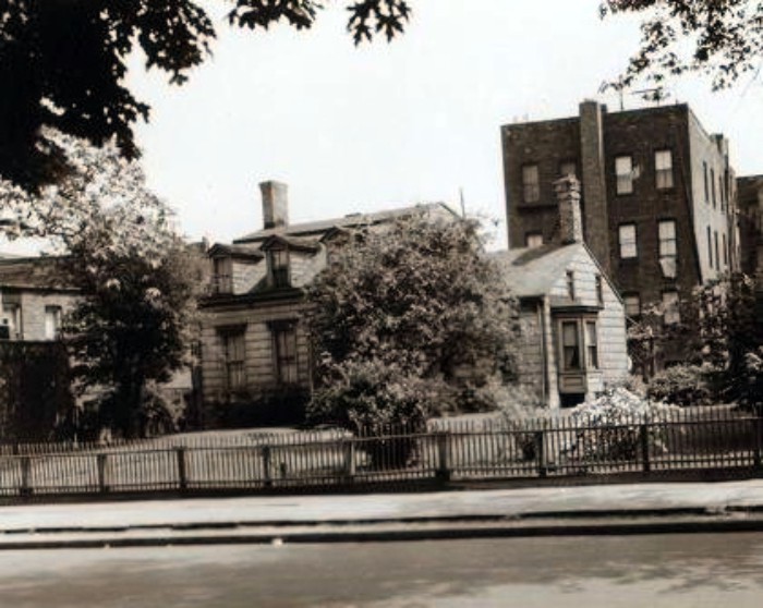
The house in the photograph was probably built in the late 1700s or early 1800s. Back then, it would have been surrounded by fields, and the land bought from, or leased from old Lefferts Lefferts, the family patriarch himself. It’s a classic gambrel-roofed Dutch farmhouse. We can’t really tell now, but the small addition on the right may even be the original house, and the larger structure built on to it later, as the family fortunes got better. Such is the case with several of our remaining Dutch houses in Brooklyn and Queens, which look exactly like this.
The gables are a classic, as well, in this type of house. The bay window on the smaller wing was probably a mid-19th century Victorian addition. The entire surface of the house is shingled. The house sits on a nice big lot, and when this photograph was taken, in 1942, it was a pretty garden spot, surrounded by row houses and three more frame houses to its left. They were probably built much later than this one, more than likely in the mid-1900s.
The town of Bedford grew up around the intersection of the old Kings Highway/Jamaica Road, which ran roughly where Fulton Street is now, and the Cripplebush and Clove Roads, which intersected at Fulton Street, and provided access from Newtown to Flatbush. Today, Bedford Avenue replaces both roads. Today, that’s only three local subway stops away from here, but in the 19th century, it was far enough away to make this area rural. As roads and streets were cut and paved, the streets around these houses saw development in spurts, a house or two here and there, some with enough land to be self-sufficient with a garden.
As roads improved, so did public transportation. Stage coaches came first, followed by horse drawn trolleys. Only half a block from here, a famous roadhouse stood on the corner of Reid and Bainbridge, a way station for stage travelers on their way to or from parts east. The Long Island Railroad passed near here, on Atlantic Avenue, with a stop in Bedford, but that really didn’t bring people out here. What did was the opening of the Brooklyn Bridge. Smart money knew that the bridge would open Brooklyn up for mass development, and land speculators and developers began buying up lots in anticipation. The bridge was begun in 1869 and didn’t open until 1883, so there was a lot of time to plan development.
The wood framed houses came first. Some built by individuals, many more by developers. Then came the masonry row houses, in groups of two or more. By the mid-1870s, most of the blocks in this area had a few small groups of Italianate row houses. The big development that produced the blocks we have now didn’t happen until the 1880s and ’90s. By that time, public transportation had greatly improved, and the area was becoming home to not only homes, but businesses, churches and large institutions, like orphanages, hospitals and old age homes.
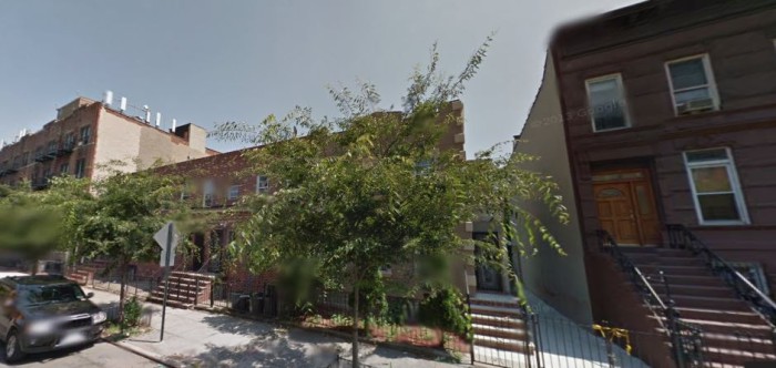
Amazingly, this house, and its three wood framed neighbors, survived the building boom, and were still here in 1942. This Dutch farmhouse was in great shape. It may have been that the photograph was taken at that time because the house was soon to become a pile of historic rubble. All four houses were destroyed to build some nondescript row housing. That row housing didn’t last all that long as built, either, and seems to have been given a facelift sometime in the last ten years.
I much prefer the Dutch farmhouse, a truly historic structure, now only a photograph. Bedford Stuyvesant no longer has any of its original Dutch buildings left, not a farmhouse, mansion or woodshed. Since the entirety of Bedford Stuyvesant is the size of many an American small city, that’s pretty sad. That said, many of the blocks just east of here were recently added to the Stuyvesant Heights Historic District. This is where Morgan Munsey and I will be leading a walking tour tomorrow at 2 pm, for the Municipal Arts Society. There are still tickets available, via their site. We hope you can join us. There is still great history and architecture here. GMAP

^^^^^^^^^
Brownstoner’s original troll.
oops. that is pacific. I recognize the house next door. I just had not remembered and wood house on that block. Apparently it was covered over to look like brownstone.
Nice job except for hideous color.
“on Pacific between Henry and Clinton’? really? I don’t think so. You must be confused. No surprise.