
Walkabout with Montrose: Historic Bedford, Brooklyn
In December of 1668, permission was given to one Thomas Lambertse to build the first public building in the new town of Bedford. Naturally, it was a tavern, to accommodate strangers, travelers and other persons traveling this way with diet and lodging and horse meals. Thirty years later, Lambertse sold a parcel of Bedford land…

In December of 1668, permission was given to one Thomas Lambertse to build the first public building in the new town of Bedford. Naturally, it was a tavern, to accommodate strangers, travelers and other persons traveling this way with diet and lodging and horse meals.
Thirty years later, Lambertse sold a parcel of Bedford land to a farmer from Flatbush Township named Leffert Pieterse.
The Lefferts family would continue to acquire land in central Brooklyn, eventually making themselves the largest landowners, largest slaveholders, and one of the wealthiest families in Brooklyn for many years to come.

The village of Bedford, also called Bedford Corners, was at the center of their fiefdom, and for over one hundred years, several Lefferts family mansions and homesteads were centered in the area of Bedford Ave, Fulton Street and Arlington Place.
Bedford remained a quiet farming community until 1776, and the bloodiest battle of the Revolutionary War, the Battle of Long Island, aka the Battle of Brooklyn. 10,000 British soldiers and Hessian mercenaries, led by General William Howe, marched through Bedford, guided by unwilling Bedford residents William Howard and his son, and headed south to surprise General Washington’s 7,000 troops.
A fierce and bloody battle ensued in the wooded hills now part of Green-Wood Cemetery and Prospect Park.

The ill prepared American forces sustained heavy losses, but thanks to a Maryland regiment providing cover, and a very foggy night, Washington and his surviving troops were able to escape across the Gowanus Creek, and eventually to Manhattan and out of NY to safety.
The British occupied Brooklyn, and then Manhattan, for the rest of the war. The Lefferts homesteads, as well as the homes of other well off Bedford landowners, such as the Suydams, Vanderbilts, Blooms and Van Endens, were occupied as officer’s housing for the duration.
The large Jacobus Lefferts house was officer’s headquarters, while the foot soldiers and Hessian mercenaries lived in excavated barracks, stretching from present day Franklin and Classon, down to Franklin and Bergen, as well as Sterling, St. Marks, Prospect Place and Park Place, now part of Crown Heights North.

As development progressed in the late 19th century, artifacts and skeletal remains were found in the remains of these redoubts.
All of the records of Bedford from before 1776 were stolen by Loyalist assistant town clerk John Rapelye. He lifted them from town clerk John Lefferts’ home, and took them to England, where they were lost. As far as numbers from the War, we do know that over ten thousand Americans lost their lives in the prison ships off Wallabout Bay, including prisoners of this battle.
In 1782, the Provisional Peace Treaty ending the war was signed in Paris. As a parting shot, the British proceeded to cut down most of the primeval forests of Brooklyn, and load them into ships to take back to England. When they left Brooklyn in 1783, there was barely one tree in Brooklyn that predated the Revolutionary War.

In Bedford today, now Bedford Suyvesant, nothing now remains of this time in Brooklyn history. The last Lefferts house remaining in the Arlington Place/Fulton St. area was torn down in 1909, and a family cemetery is rumored to be in an empty lot on the corner of Hancock and Bedford, although no headstones are present.
There are no other remaining homes in Bed Stuy from this era. The Lefferts family, the children of Judge Lefferts Lefferts, who was a boy during the British occupation of his home, sold off most of the family land by the mid 1800’s, allowing the development of most of Bedford Stuyvesant, Stuyvesant Heights, and Crown Heights.
Another branch of the family went on to sell off the parcels which became Lefferts Manor, in nearby Flatbush. The Lefferts Homestead, now in Prospect Park, is the last remaining home of this large and wealthy family.

Sketches, photographs, and descriptions of patriarch Jacobus Lefferts’ manor, built in 1768, which used to stand on Arlington Place, show a large columned Federal/Greek Revival stone house, which was said to have mahogany doors, 10 foot windows, solid silver doorknobs, and fireplaces large enough to walk in.
This was the house commandeered by British officers, surviving until the house was torn down in 1893. The town of Bedford was one of the original villages making up the township of Brooklyn.
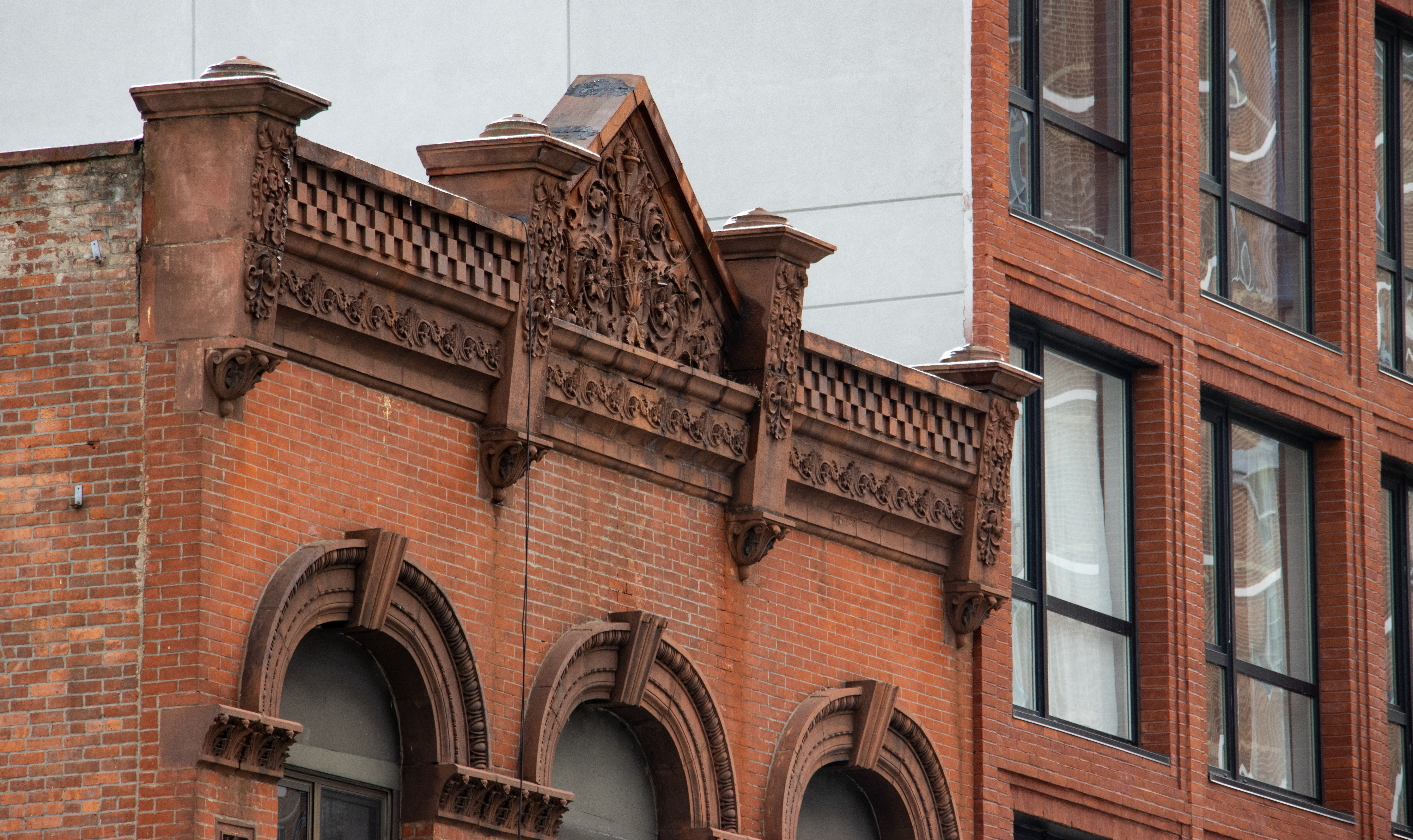
By the late 1800’s, it was an upper middle class enclave of homes, businesses and churches, and thrived in part, for the same reason it was so valued by the British during the Revolution: as a transportation hub, where important roads, trails, and later railways and trolleys connected Brooklyn to the rest of Long Island.
The 31st annual Bed Stuy House Tour is this Saturday, October 17th. The self guided tour begins at the magnificent Boy’s High School, at the corner of Putnam and Marcy Avenues, and runs from 11-4. See the Brownstoners of Bed Stuy website for more details. http://www.brownstonersofbedstuy.org/. My Flickr page shows some of the great architecture of Bed Stuy.
Much of the historic background for this article is from Images of America: Bedford-Stuyvesant, by Wilhelmema Rhodes Kelly, a wealth of information on this great community.

Thanks all, for the kind words. I plan on doing stories on other neighborhoods, especially since this one was so well received. History is so much more interesting when you can focus on real people, or places that you can still visit, albeit changed.
M4L, Boy’s High School is now home to two charter schools, as well as other educational programs. It is currently getting a face lift, and looks spectacular.
Benson, you are correct, Bedford did include much of what we now call Crown Heights North. As the St. Mark’s District became the new upper crust area, the Bedford name slowly phased out, and the Crown Heights name became more popular, although old timers still refer to some parts of CH as Bed Stuy to this day. That was also in part due to electoral zones, police precincts, etc, as well as shared ethnicities, cultures and economics. The Crown Heights North/South name was developed by the LPC in the 70’s when they were surveying the area for landmarking. There is a big difference in architecture on each side of EP, so it made sense.
The Stuyvesant Heights name is old, and combining the two, as the borders of Bedford Stuyvesant include both streets, just became the way to define the community. Of course it is a bit more complicated than that, but that’s the general gist of it.
The Onderdonk house is technically in Ridgewood and is fundraising for a new roof:
http://onderdonkhouse.org/fundraiser.aspx
God, how I love these little Dutch relics. What a shame that nothing survived in Bed-Stuy–a good reminder that what we take for granted today is tomorrow’s ephemera, lost if not preserved. I am disgracefully unfamiliar with Bed-Stuy and plan to finally do the house tour this year. Thanks, MM!
is the killer boys high school building being used for anything currently?
more such write-ups for the other hoods PLEASE.
Great stuff, Montrose!
“as are we”
Fascinating, as always, Montrose.
Brooklyn is lucky to have you, as our we.
Minard, you are a wealth of local historical info.
Yes- I just looked and the house was nowhere near as fancy either.
salt marsh? Ok, its not the Commandant’s digs