
How Will Brooklyn Travel in 2027? 5 Projects That Could Transform the Borough
Let’s take a look at five transportation projects that could reshape how Brooklynites get around the borough.
There’s no shortage of options for getting around Brooklyn — subway, bus, bike, car, boat and foot, to name a few.
But what could things look like a decade from now? Let’s take a look into the future.
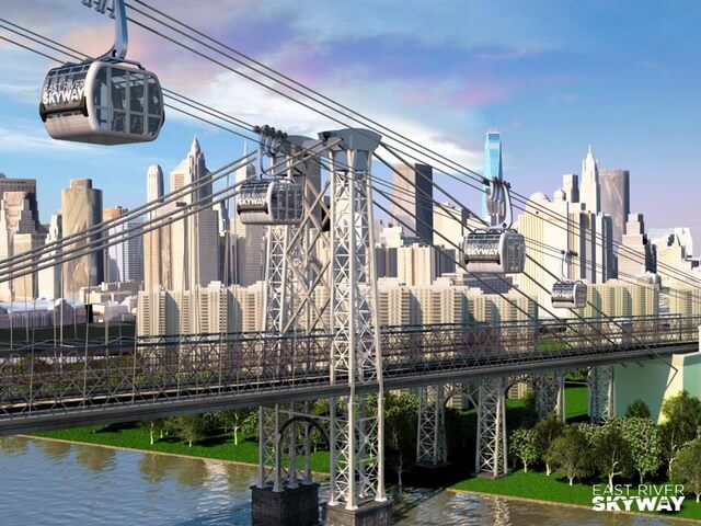
East River Skyway
The looming L train shutdown is a subject that makes Williamsburgers shudder. But what if there was another way?
That’s where the East River Skyway comes in.
The skyway is a proposed “high-speed aerial gondola” (not unlike the Roosevelt Island Tramway) that would connect Brooklyn to Manhattan. It’d be able to carry 100,000 people a day across the river, and could be built relatively quickly in time for the L train shutdown, in three planned phases that would expand it both north and south in Brooklyn.
Proposed by Dan Levy, president of City Realty, the project has yet to gain funding or formal approval, but has garnered favorable sentiment from several local Brooklyn politicians, including Councilman Stephen Levin. It wouldn’t transport as many as the L, but at least it’s something.
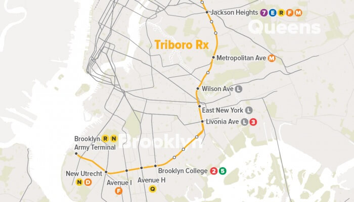
Triboro RX
If the 2nd Avenue subway construction saga is any indication, laying down subway tracks and opening new lines in New York City is a less than certain proposition.
But what if the rails were already there?
That’s where the Triboro RX comes in.
The 24-mile new above-ground subway line would follow an existing freight train right of way and connect the outer parts of three boroughs: Brooklyn, Queens and the Bronx. The Regional Planning Association likens it to a “wheel connecting the subway’s spokes,” and the new line would provide connections to 17 subway lines and four regional rail lines. The project has the potential to cut travel time significantly, change the relationship of far-flung areas with the rest of the city, and serve as many as 100,000 riders daily. It would aid many underserved neighborhoods in eastern Brooklyn and potentially affect property values in these areas as well.
One potential issue is an ongoing need for freight train service, which might mean freight trains will need to share the line with passenger cars.
The proposal right now is just that — a proposal, and has yet to gain formal funding or backing.
Increased Ferry Service in Brooklyn
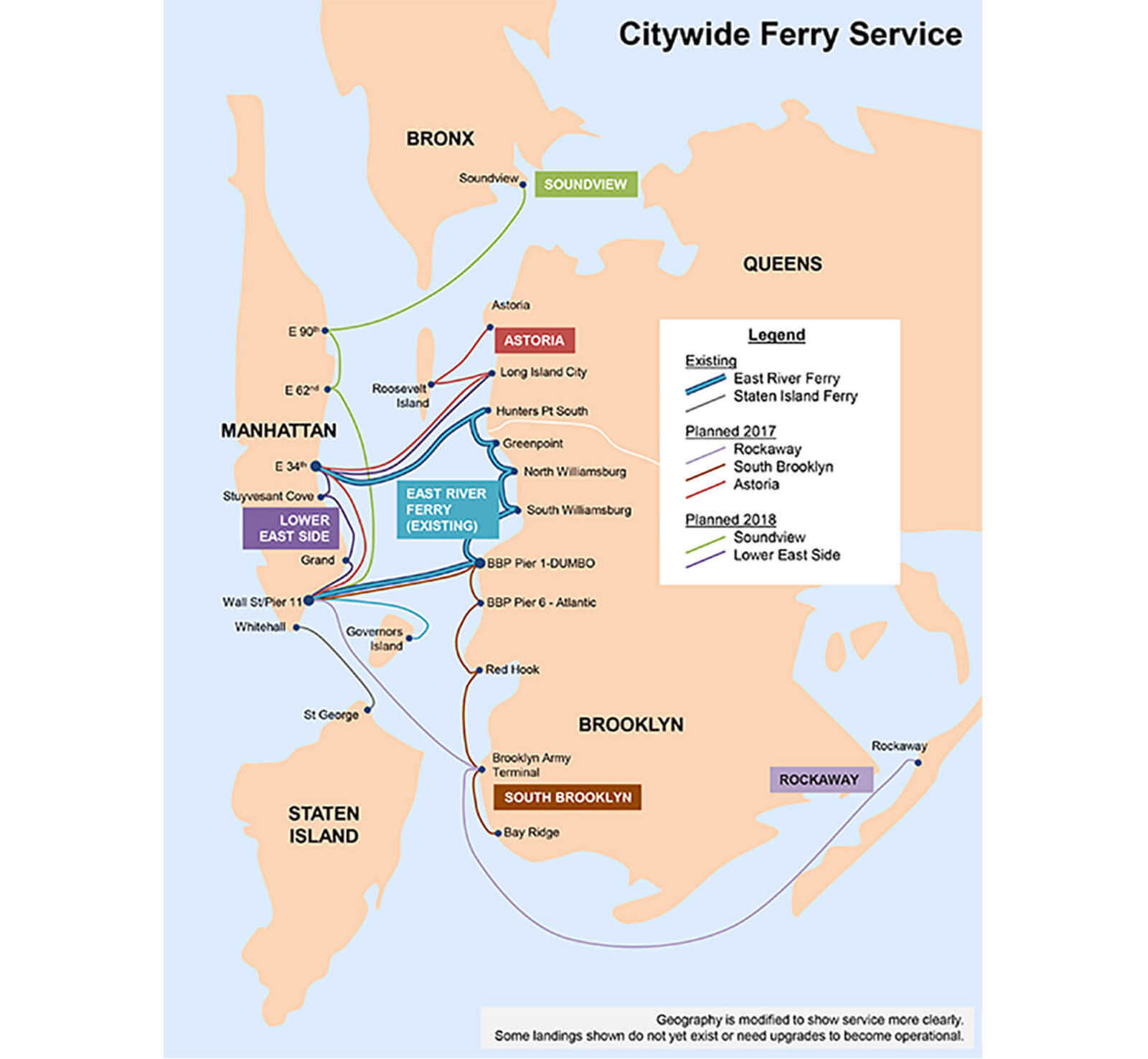
It can be easy to forget with the surrounding urban sprawl, but Brooklyn sits on an island. It’s had a long history of ferries, which prior to the opening of the Brooklyn Bridge, were the way Brooklynites moved goods and themselves across to Manhattan and out to the rest of the region and country.
Ferries continue to be useful today in waterfront areas from Sunset Park to Greenpoint.
The new Citywide Ferry Service will begin this year, with five new routes that expand upon the existing East River Ferry. In 2018, two more routes will follow.
The South Brooklyn line of the ferry, scheduled to open later this year, will connect Dumbo to Bay Ridge, with stops at Pier 6, Red Hook, and Brooklyn Army Terminal and a connection to Manhattan at Wall Street via Dumbo. Going forward, there’s also a plan to connect Brooklyn Army Terminal to Wall Street and the Rockaways via express ferries.
What does this mean for a growing, evolving Brooklyn?
The benefits are two-fold. First, ferries provide easier access for hard to reach parts of the borough, such as Red Hook and Brooklyn Army Terminal, which could spur more economic growth. Second, ferries will be an important route into Manhattan for Brooklynites cut off from Manhattan by the L train shutdown in 2019.
With a price pegged to the $2.75 cost of a subway ride, boat travel will be a relatively affordable breath of fresh air (literally) for travelers who spend a great deal of time underground.
The Brooklyn-Queens Connector or BQX
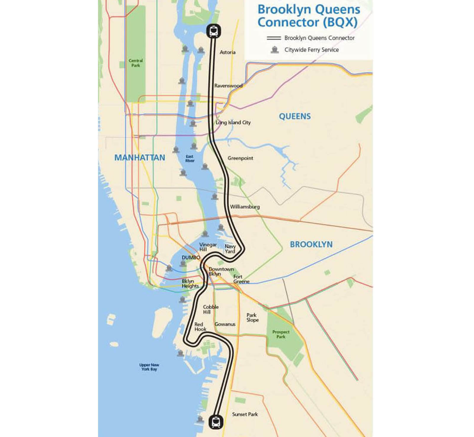
It’s not a bus, and it’s not a train — it’s something in between, one Brooklyn hasn’t seen in many years.
It’s a streetcar dubbed the BQX, and it aims to connect areas of the Brooklyn waterfront that have long been without subway service.
Stretching from Bay Ridge to Astoria in Queens, the BQX has potential to cut commute times for Brooklynites who have north-south transit paths in the western part of the borough and would go to otherwise underserved areas, like Red Hook. But it won’t come cheap — the initial price tag on the project is $2.5 billion.
The new streetcar would carry more than 15 million people a year, reduce greenhouse gas emissions (by cutting down on bus and car usage) and bring access to job opportunities to more Brooklynites, according to the New York City Economic Development Corp and advocates Friends of the BQX. Additionally, raised tracks in Red Hook would create a flood barrier, killing two birds with one stone.
Mayor de Blasio has embraced it, and the city revealed potential routes in November. Public review will take place this year.
There’s talk of the BQX opening by 2024. If it does open on time, it would be a game changer for the Brooklyn waterfront.
Utica Avenue Extension
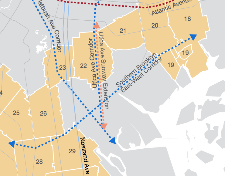
The 2nd Avenue Subway’s first phase is finally — mercifully — finished. So what subway extension will the city tackle next?
It may just be here in Brooklyn, if Mayor de Blasio has his way.
The subway the mayor backs would extend the 4 train line from Eastern Parkway to Kings Plaza, bringing the subway to an area of Brooklyn that has none. A formal study on the issue was funded two years ago as part of the MTA’s $27 billion capital program, but so far no study has come out.
The line would be a boon to people living in East Flatbush and Flatlands, and would likely drive up property values there, but this one seems to be a long shot.
Related Stories
- Hated, Beloved and Highly Used: The Past, Present and Future of the Brooklyn-Transforming BQE
- These Six Brooklyn Subway Stations Have Wi-Fi, and Now, Subway Reads
- Express F Train Tradeoffs: Shorten Commutes in Brownstone Belt or Southern Brooklyn?
Email tips@brownstoner.com with further comments, questions or tips. Follow Brownstoner on Twitter and Instagram, and like us on Facebook.
What's Your Take? Leave a Comment