
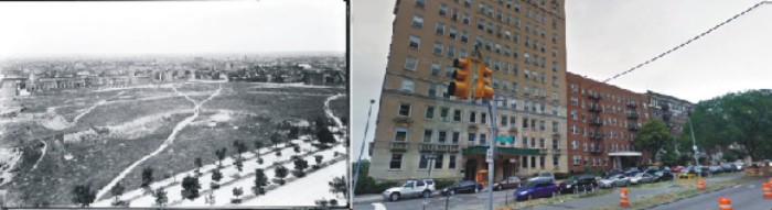
Past and Present: Eastern Parkway, Looking North Over Brooklyn
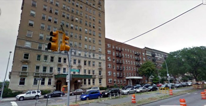
A look at Brooklyn, then and now. Few scenes in Brooklyn look more different than the past and present scenes of Eastern Parkway in 1900 and now. Today, the area is a vastly built up collection of streets and buildings, with large apartment buildings lining the north side of Eastern Parkway. But 114 years ago,…
A look at Brooklyn, then and now.
Few scenes in Brooklyn look more different than the past and present scenes of Eastern Parkway in 1900 and now. Today, the area is a vastly built up collection of streets and buildings, with large apartment buildings lining the north side of Eastern Parkway. But 114 years ago, it was a large open field with a couple of dirt roads running through it. There certainly are few clues that twenty-five years after this photo was taken, most, if not all of this space would be built on.
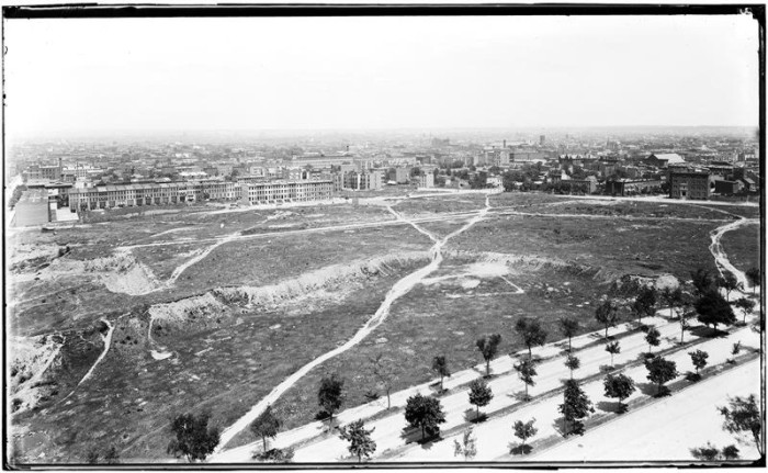
The photograph was taken from the tower of the Mount Prospect Reservoir, which once stood on a rise, about where the Children’s Entrance at the rear of the Central Branch of the Library is now. Unfortunately, I can’t replicate the height and the great angle that long ago photographer had in taking his photograph facing north towards Manhattan. What an amazing amount of Brooklyn he captured in this photo, which shows Brooklyn spreading north. The photograph captures parts of Prospect Heights, Crown Heights, and in the misty horizon, Fort Greene, Brooklyn Heights, Dumbo and Williamsburg.
One of the great things about many old black and white photos, the resolution is superb, and the details one can pick out are just amazing. I’m looking at the photo from a relatively small laptop screen. I would imagine that someone with a much larger screen may be able to pick out landmarks that are too small on my screen, but even so, I see quite a lot. Let’s see what we’ve got here:
Of course, in the foreground – Eastern Parkway. The trees are only a few years old, allowing us to see the eastbound and westbound lanes, with the median strip in the center, and tree-lined sidewalks. Far on the other side of the field are the newly built row houses on Sterling and Park Places built by developer William J. Reynolds. Both of these groups of houses were only about three years old when this photograph was taken, as they were built in 1897. That’s probably Vanderbilt Avenue stretching north in the far left of the picture.
You can see some interesting buildings in the background. Panning right from Vanderbilt and north of the Reynolds row houses, the long factory building about in the middle is the Knox Hat Factory, on the corner of Grand Avenue on St. Marks Avenue. Knox’s prominent clock tower on the corner of the building is quite visible. Moving east a bit more and you come to the Nassau Brewery complex on Dean, Bergen and Franklin. There are several building in this complex, but I think we can just see what may be the ice house and a smoke stack.
Just beyond that is the castle-like tower of the 23rd Regiment Armory, on the corner of Bedford Avenue and Pacific Street. I think I can just make out the roofline of the Imperial Apartments, but it’s hard to tell. I see several church steeples, but I can’t see them well enough to identify them. I also don’t know what the large tenement or factory building is on the right of the photo. There were once quite a few factories in Prospect Heights and on the border of Crown Heights. There are some other large buildings in the background that are in Bedford Stuyvesant, but unfortunately, on my computer screen, they are just dark lumps. I’d love to hear from anyone if they can identify anything else.
And there you have it. When the site for Prospect Park was originally chosen, before the Civil War, this large field, as well as the reservoir, was to be a part of the park. The land was purchased outright, or obtained through eminent domain. After the war, Calvert Vaux and Frederick Law Olmsted replaced the original designer, and they moved the park’s boundaries to what we know today. The city of Brooklyn was stuck with a lot of extraneous land. They held on to the land around the reservoir, where the Library, Brooklyn Museum and Botanic Gardens are, but they sold the land that makes up much of present day Prospect Heights. It was sold off to developers like William Reynolds.
The land was graded and leveled off, pretty much, and cleared of trees and vegetation. While waiting for buyers, the land eventually had dirt roads cut through it, and it looks like a baseball diamond was worn into the ground. Hey, why not, the land was just sitting there. But they wouldn’t be playing baseball there for long. By the late teens and early 1920s, the large luxury apartment buildings began to go up. Union Temple’s building was built in 1925. By the 1940s, the reservoir would be filled in and the tower torn down. Eastern Parkway would never look like this again. GMAP
What's Your Take? Leave a Comment