
Queenswalk: Astoria Park
Queens has some great parks. For me, a great park has nature in abundance, some fascinating history, and perhaps a special “thing” that makes it a destination, not just any old place to walk and run, or ride your bike, or settle down to read a good book. Of course, to establish a great park…

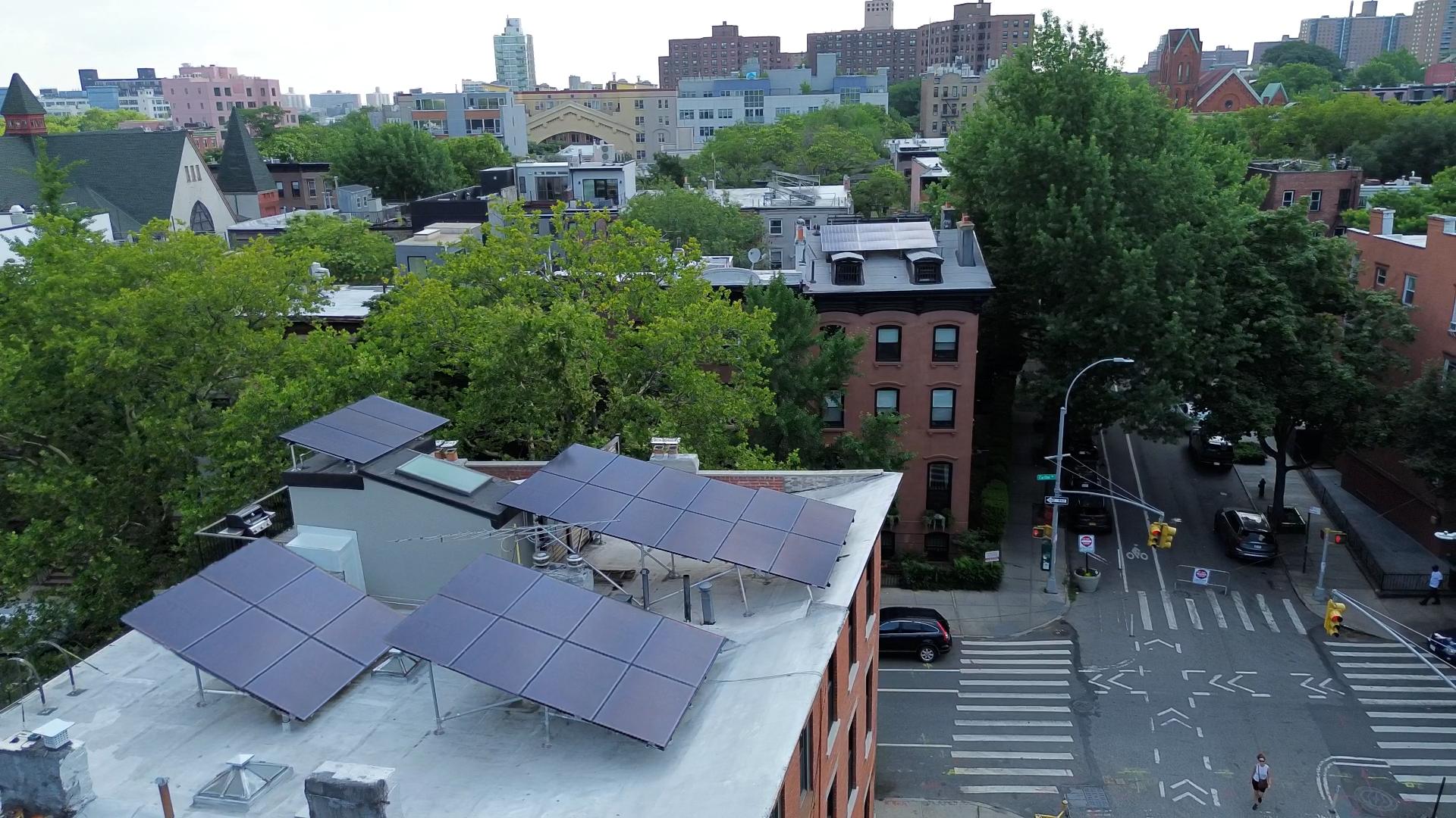
Queens has some great parks. For me, a great park has nature in abundance, some fascinating history, and perhaps a special “thing” that makes it a destination, not just any old place to walk and run, or ride your bike, or settle down to read a good book. Of course, to establish a great park you have to work with what you are given by nature and location. So if you are given a fantastic shoreline overlooking the East River, Ward’s Island and Manhattan, and are nestled near two picturesque and historic bridges, one of which spans one of the city’s most dangerous and history-filled waterways, then you have the makings for Astoria Park.
Astoria Park is big, just shy of 60 acres, making it one of the largest open spaces in Queens. Long before the Dutch showed up, this was home to Native Americans; from some accounts, a tribe called the Marechkawieck, who had a village near the present day park. They grew maize on this land, fished in the Hell Gate, and got fresh water from a stream that still flows underneath the park. By the mid-1600s, they had ceded the land to the Dutch, who by hook or crook had gotten hold of all of the land that made up New Amsterdam from the various tribes in the region. The Dutch divided up the land, and the parkland ended up in the larger holdings of a man named Richard Hallet.
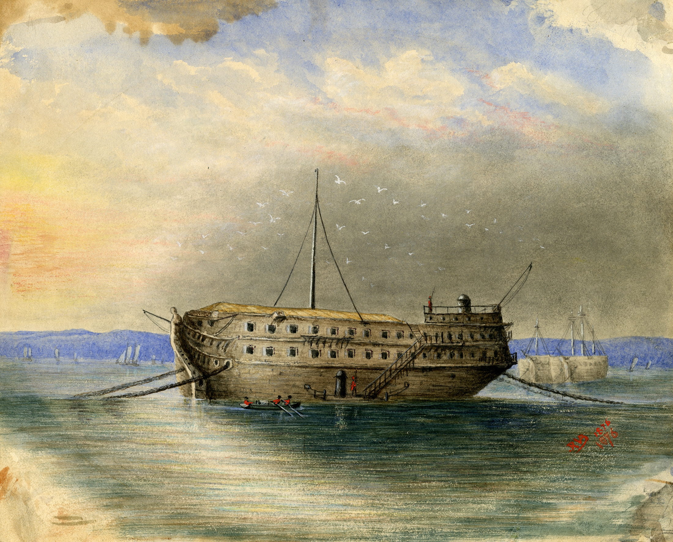
The English won New Amsterdam from the Dutch by the end of the 1600s. During the Revolutionary War, both English and Hessian soldiers were camped here, as all of what is now New York City was occupied by the British and their allies for almost the entirety of the war. In 1780, the British frigate Hussar, and five million dollars’ worth of cargo sank in Hell Gate’s dangerous waters, and has never been recovered. Salvage teams recovered the ship’s cannon, but were unable to get anything else.
The history of Hell Gate is part of the history of this park. The name, fitting as it is, is actually a corruption of the Dutch “Hellegat,” which means “clear strait,” referring to the entire East River. The word is used often in Dutch and Low Country descriptions. But calling the strait “Hell Gate” certainly fit, as well. The Hell Gate channel contains some of the deepest water in New York Harbor. But it was extremely rocky, and the convergence point of tide-driven currents from the Long Island Sound, Harlem River, Upper Bay of New York Harbor, and smaller bodies of water, most of which have been filled in over the course of the last two hundred years.
This convergence means that all kinds of strong currents, even whirlpools are out there. You can see some of those currents from the shore, but the really strong ones are underneath the water. For centuries, a passage through the Hell Gate took a skilled mariner, and even then, the large rocks were waiting to kill ships and people. The Hussar was not the first, or the last disaster in the Hell Gate. Hundreds of ships, large and small, went down in the Hell Gate.
The most famous and tragic disaster was the destruction of the General Slocum, a steamship tourist vessel that burned and sank in the Hell Gate in 1904. It was carrying members of St. Marks German Lutheran Church in Manhattan, to a picnic on Long Island. The passengers were mostly women and children. The ship caught fire on in the East River, and all but 200 of the 1300 people on board burned to death or drowned in the disaster. Up until 9-11, it was the worst loss of life in New York City history.
Beginning in 1850, and proceeding for the next 70 years, the Army Corps of Engineers tried to clear the strait with explosives, blowing up the big rocks, and trying to widen the passageway. In 1885, they blew up a large rock called Flood Rock with the biggest planned explosion ever undertaken until atomic testing. The Corps used 300,000 pounds of explosives to turn the rock to rubble, in a blast that sent a geyser of water 250 feet in the air, and a blast that was felt as far south as Princeton, NJ. The resulting rubble was used to create landfill that joined two of the smaller islands in the river, creating Mill Rock Island. Today, it’s a small uninhabited island in the middle of the river used mainly as a bird sanctuary.
Meanwhile, during the 19th century, the heights overlooking the river were built up with summer cottages for the wealthy. After the Civil War, the Queens waterfront took off as a commercial area, filling up the shoreline across from Manhattan, and the cottages disappeared, one by one. But by the end of the 19th century, people wanted parkland. Parks have long been an important part of city living, as city planners and government officials alike could see the importance to health and quality of life in not filling up every acre of the city with buildings.
The people of Queens also wanted public access to the shores of the river. In 1913, the city acquired 56 acres of land along the river for a park. It was originally called William J. Gaynor Park, after the just departed mayor, but the name was soon changed to the East River Park. In 1913, the name was officially changed once again to Astoria Park, named after the neighborhood of Astoria. The village of Astoria was named in 1839 by its founder, Stephen Halsey, for his friend, John Jacob Astor.
The park was established with two playgrounds, six tennis courts, an athletic field, three baseball diamonds, a wading pool, bandstand, paths and walkways, and comfort stations. In the 1930s, Parks Commissioner Robert Moses used WPA money to build the massive swimming pool that is the centerpiece of the park. An avid swimmer himself, Robert Moses loved swimming pools and built eleven pools in the hot summer of 1936, all across the city. The pool in Astoria Park is the oldest and largest of these public pools, and opened on July 4th, 1936. It is 54,450 square feet, and was large enough to become the training and qualifying pools for the 1936 and 1964 Summer Olympics.
The original parkland was expanded twice. The Parks Department acquired a 4.5 acre parcel beneath the Triborough Bridge in 1937 and a five acre strip, called Ralph DeMarco Park, along the East River in 1969. All of New York City’s Parks were neglected in the lean years of the city during the 1970s, but the park underwent a massive rehab in the 80s, which replaced a lot of the equipment, the bathrooms, drainage systems, benches and other features of the park.
Astoria Park gives parkgoers a beautiful and unique view of the Triborough (Robert F. Kennedy) Bridge, completed in 1936, the same year as the pool. The bridge, which is actually three bridges, connects Queens, Manhattan and the Bronx. On the other side of the park, the Hells Gate Bridge, a railroad bridge, spans Queens and Wards Island, technically Manhattan. It was completed in 1916. The styles of the bridges are so different; they form a wonderful contrast and show two very different marvels of engineering.
And then you have the views of the Manhattan skyline and the view from Charybdis Park, one of the playgrounds, looking over to Scylla Point on Wards Island. The two points were named by former Parks Commissioner Henry Stern for the Greek mythological water hazards in the Odyssey. Fitting, given the waters between them. Greek mythology, maritime history, natural beauty, and the wonders of man’s ingenuity and creativity. What more could a park ask for? So what if it’s winter! Get ye to Astoria Park!
(Photograph:Wikipedia)


What's Your Take? Leave a Comment