
Flatbush Could Soon Get Two New Landmarked Historic Districts
The city’s Landmarks Preservation Commission voted to calendar the proposed districts of freestanding houses.

Houses along Rugby Road in Beverley Square West in 2019. Photo by Susan De Vries
In an unexpected move, two new historic districts have been proposed for the area south of Prospect Park, once part of the historic town of Flatbush. The city’s Landmarks Preservation Commission voted unanimously Tuesday to calendar the proposed Beverley Square West and Ditmas Park West historic districts, a step that sets up forthcoming public hearings.
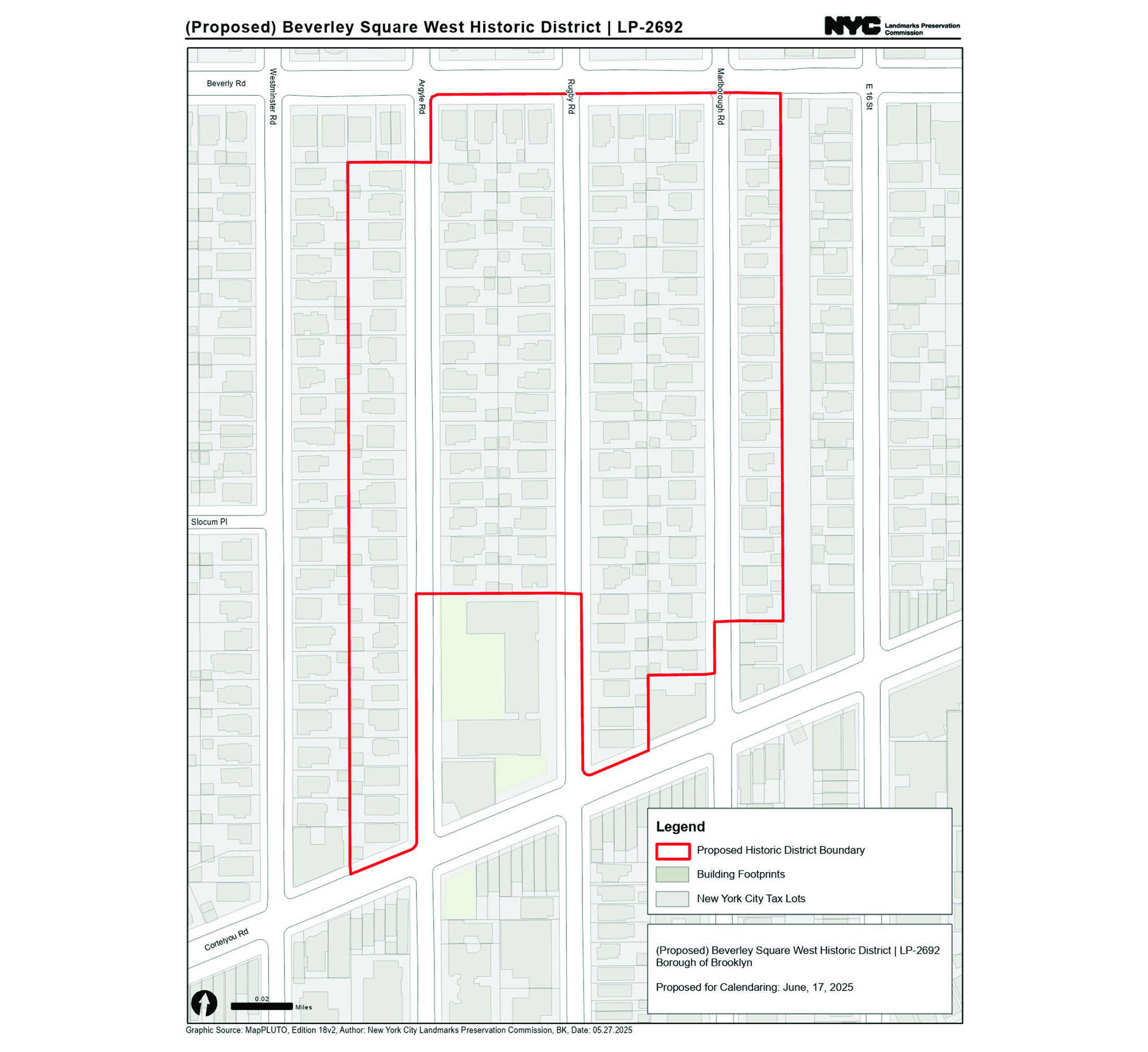
The proposed Beverley Square West Historic District spans Argyle and Marlborough roads between Beverley and Cortelyou, while the proposed Ditmas Park West Historic District lies just south and west, between Westminster and Marlborough from Dorchester Road to Ditmas Avenue.
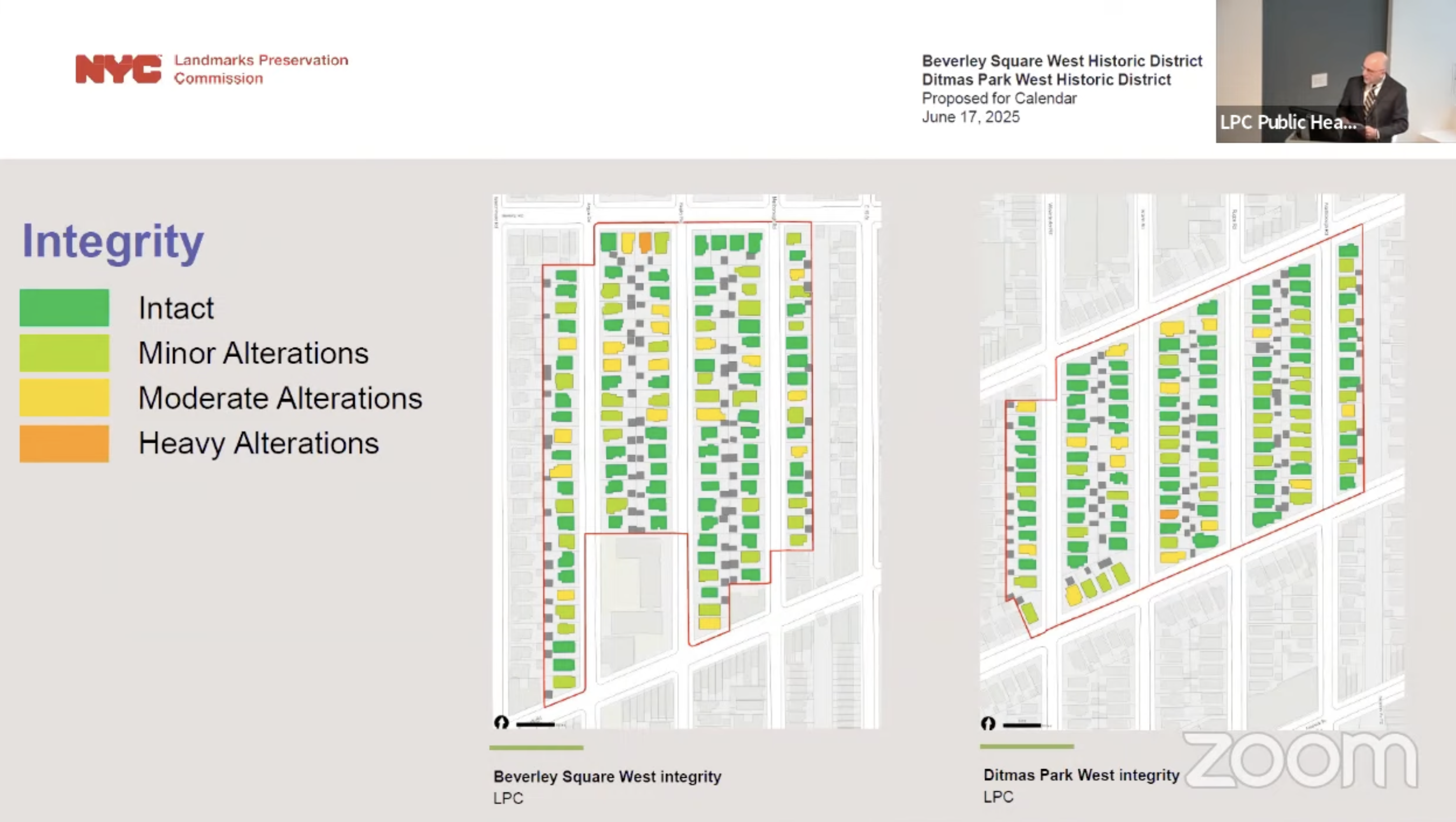
LPC researcher Michael Caratzas told commissioners that both areas represent well-preserved examples of early suburban development in Flatbush, with freestanding houses built between the mid-1890s and 1910. He said the LPC’s research department considers these two areas the strongest remaining parts of historic suburban Flatbush not yet landmarked, with over 85 percent of houses in each district retaining high architectural integrity and having only minor alterations.
“In both districts, historic streetscapes of freestanding houses continue to appear much as they did in the early 20th century,” he said.
The districts reflect the history of suburban expansion in Flatbush, which took shape in the late 19th and early 20th centuries, Caratzas said. Flatbush was an independent town before it became part of Brooklyn in 1894. Brooklyn, in turn, was incorporated into New York City in 1898.
LPC has already designated nine districts in the former town of Flatbush, which included the area now known as Prospect Lefferts Gardens and the neighborhoods south of what is now Prospect Park, among others. Adjacent to the two proposed districts under consideration are the Prospect Park South and Ditmas Park historic districts, designated in in 1979 and 1981, respectively. They also comprise suburban-style freestanding houses rather than row houses.
Caratzas said the proposed Beverley Square West Historic District would include 119 houses along Argyle, Rugby, and Marlborough roads, bounded by Beverley Road to the north and Cortelyou Road to the south.
The neighborhood dates back to 1894—five years before development began on nearby Prospect Park South—when local builders started constructing houses in what was then known as Matthews Park, named after the area’s former landowner, Caratzas told commissioners. One of its earliest homes, the Queen Anne-style house at 268 Argyle Road, was designed by architect John A. Davidson in 1895.
While the northern section of the district was developed first, the southern half—formerly farmland known as the Catherine Lot or Voorhees Farm—remained untouched until 1901, when Brooklyn developer Thomas B. Ackerson purchased the property, Caratzas said. Ackerson named the new development Beverley Square West, echoing his similarly named Beverley Square East project just across the Brighton Line. Ackerson hired well known Brooklyn architects, including A. White Pierce, to design houses that were largely completed by 1905.
In 1902, Ackerson took steps to unify the area, having the numbered streets renamed to Argyle, Rugby, and Marlborough roads—mirroring the pattern in Prospect Park South, Caratzas said.
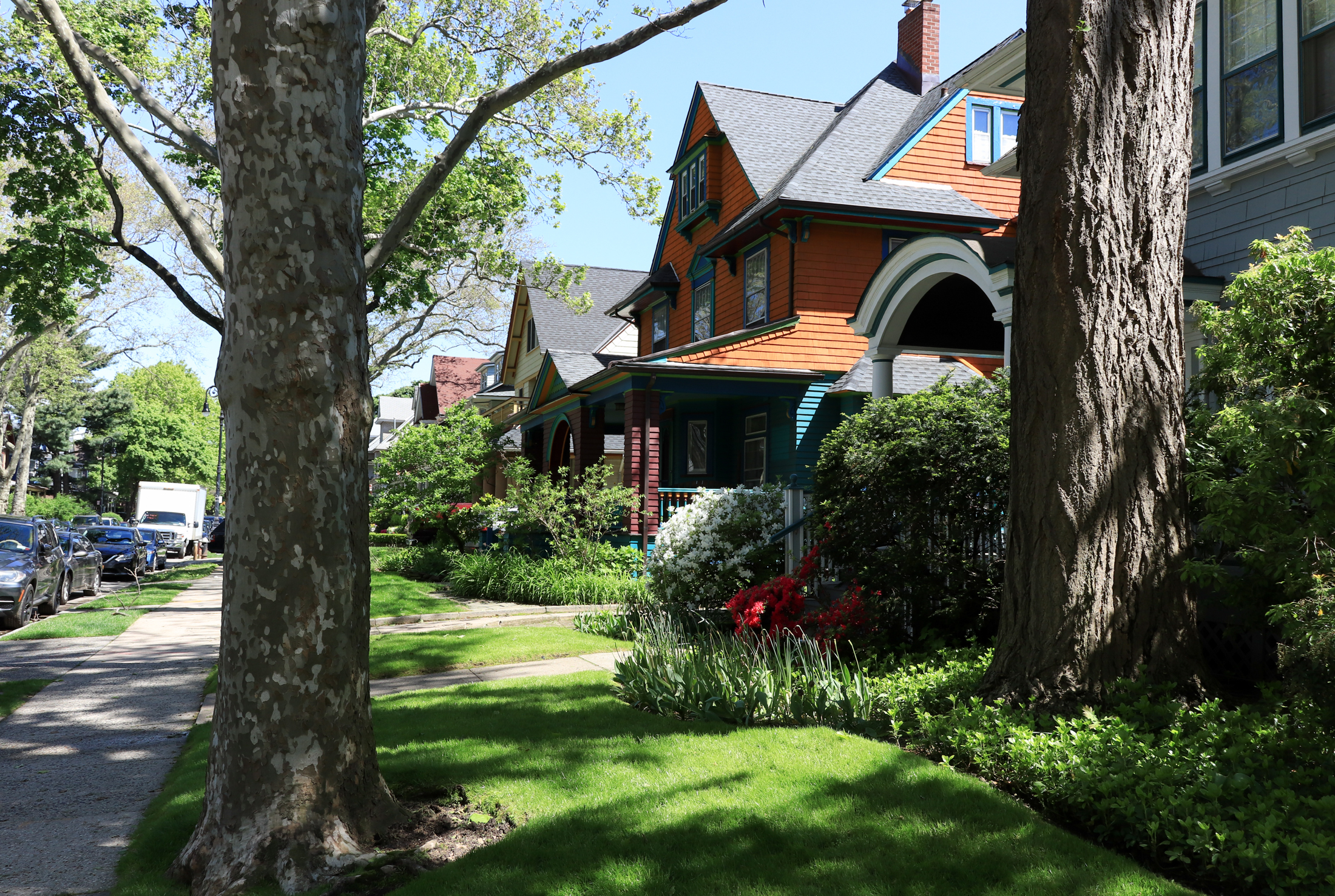
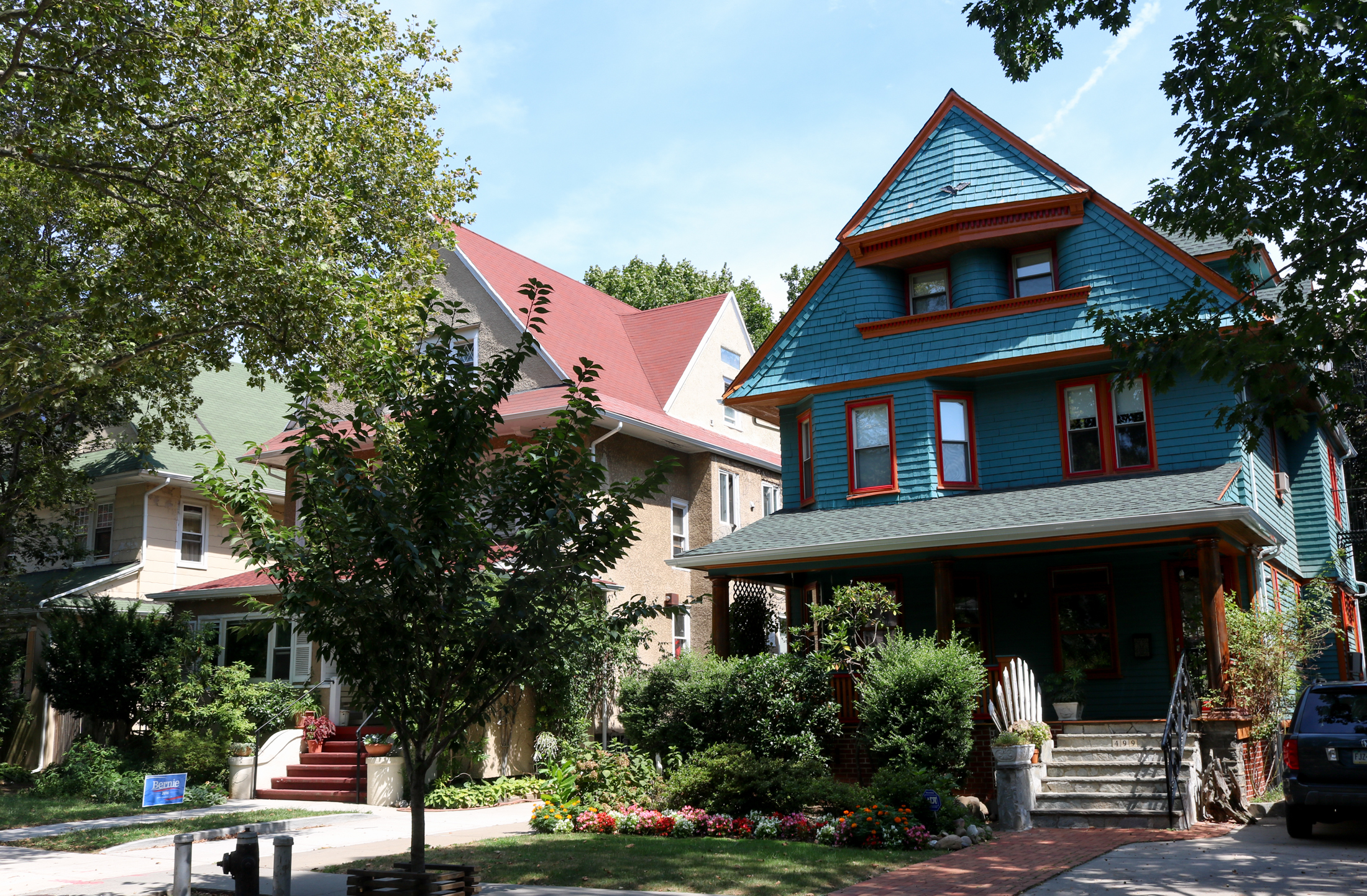
Architecturally, the earliest homes in the Matthews Park section were built in the Queen Anne style, with steep rooflines, decorative gables, and asymmetrical façades, according to Caratzas. Colonial Revival was also popular with its symmetrical designs, classical columns, fanlights, and Palladian windows. Many homes in the district blend elements of both styles.
“Though diverse in style and design, the houses of Beverley Square West form harmonious suburban streetscapes, little changed from the early 20th century,” Caratzas said.
Detached wood-frame houses are set back behind open lawns, with continuous green space and intact grassy strips between the sidewalks and the road. Nearly all the homes were built between 1894 and 1905, with just a handful completed by 1910. “This rapid period of development gives Beverley Square West remarkable architectural cohesiveness,” Caratzas told commissioners.

A block south of the proposed Beverley Square West Historic District and adjacent to the already-designated Ditmas Park Historic District is the proposed Ditmas Park West Historic District, which includes 128 houses along Westminster, Argyle, Rugby, and Marlborough roads, as well as Ditmas Avenue. It is bounded by Dorchester Road to the north and Ditmas Avenue to the south.
This leafy enclave was largely developed by Lewis H. Pounds and his Manor Realty Company, said Caratzas. In 1902, Pounds purchased the former John Ditmas farm, which Caratzas said had been worked by enslaved people into the 19th century.
After acquiring the property, which straddled both sides of the Brighton railroad line, Pounds began developing the eastern section as Ditmas Park. In 1903, he turned his attention west of the tracks, launching Ditmas Park West as a separate suburban development.
Unlike Ditmas Park, which was marketed as a community for the well-to-do, Caratzas said, Ditmas Park West was envisioned as a more accessible but high-quality neighborhood. In ads from the time, the development was pitched as offering “dwellings of moderate cost in a select neighborhood,” backed by durable infrastructure and permanent street improvements. After laying out the streets and utilities, Pounds sold many of the individual lots to local builders, who moved quickly to construct homes.
That fast-paced growth gave Ditmas Park West the same kind of architectural unity seen in neighboring Beverley Square West, Caratzas said. All of the houses in the proposed district were built between 1903 and 1910, forming “strong architectural and historical cohesiveness due to its rapid development and uniform building type of freestanding houses,” Caratzas said.
Most of the houses draw from the popular Queen Anne style, with asymmetrical forms and ornamental flair, and many also incorporate features from other styles of the time. Colonial Revival influences can be seen in the porches and classical details, and deep roof overhangs and boxy silhouettes reflect the rise of the Prairie style, influenced by architects like Frank Lloyd Wright, Caratzas added.
Some homes also use elements of the Shingle style, recognizable by curved forms and continuous shingled surfaces, an aesthetic Caratzas said originated in upscale Gilded Age resorts like Newport and the Berkshires.
“Today, the historic landscape features of Ditmas Park West are largely intact, contributing to its lush suburban feel,” Caratzas said. “Front lawns remain continuous and open in front of houses dating from the first decade of the 20th century.”

At the end of the presentation, LPC Chair Sarah Carroll said the two proposed historic districts “would continue the story and history of the development of the neighborhood,” and she recommended the commissioners vote to calendar the proposals, which they did unanimously.
The two historic districts will now be added to LPC’s calendar for public hearings.
Related Stories
- Locals Celebrate Creation of Bed Stuy’s Willoughby-Hart Historic District
- Brooklyn Gained One Individual Landmark and One Historic District in 2024
- Preservation Report Finds Designations Per Year at All-Time Low Under Adams
Email tips@brownstoner.com with further comments, questions or tips. Follow Brownstoner on Twitter and Instagram, and like us on Facebook.
Wonder why they dont extend the boundary of Beverly Square West to Stratford and grab the houses on those little side streets (Matthews, Lewis, and Slocum).