
Drool Over Historic Maps of the Borough at Brooklyn Historical Society's New Online Collection
While the history-stuffed Othmer Library has been closed to researchers during the pandemic, lovers of the borough have a new reason to rejoice with the launch of Brooklyn Historical Society’s map digitization project.

Plans for a penitentiary on Crown Street, circa 1850s. Map attributed to T. G. Bergen via Brooklyn Historical Society
While the history-stuffed Othmer Library has been closed to researchers during the pandemic, lovers of the borough have a new reason to rejoice with the launch of Brooklyn Historical Society’s map digitization project.
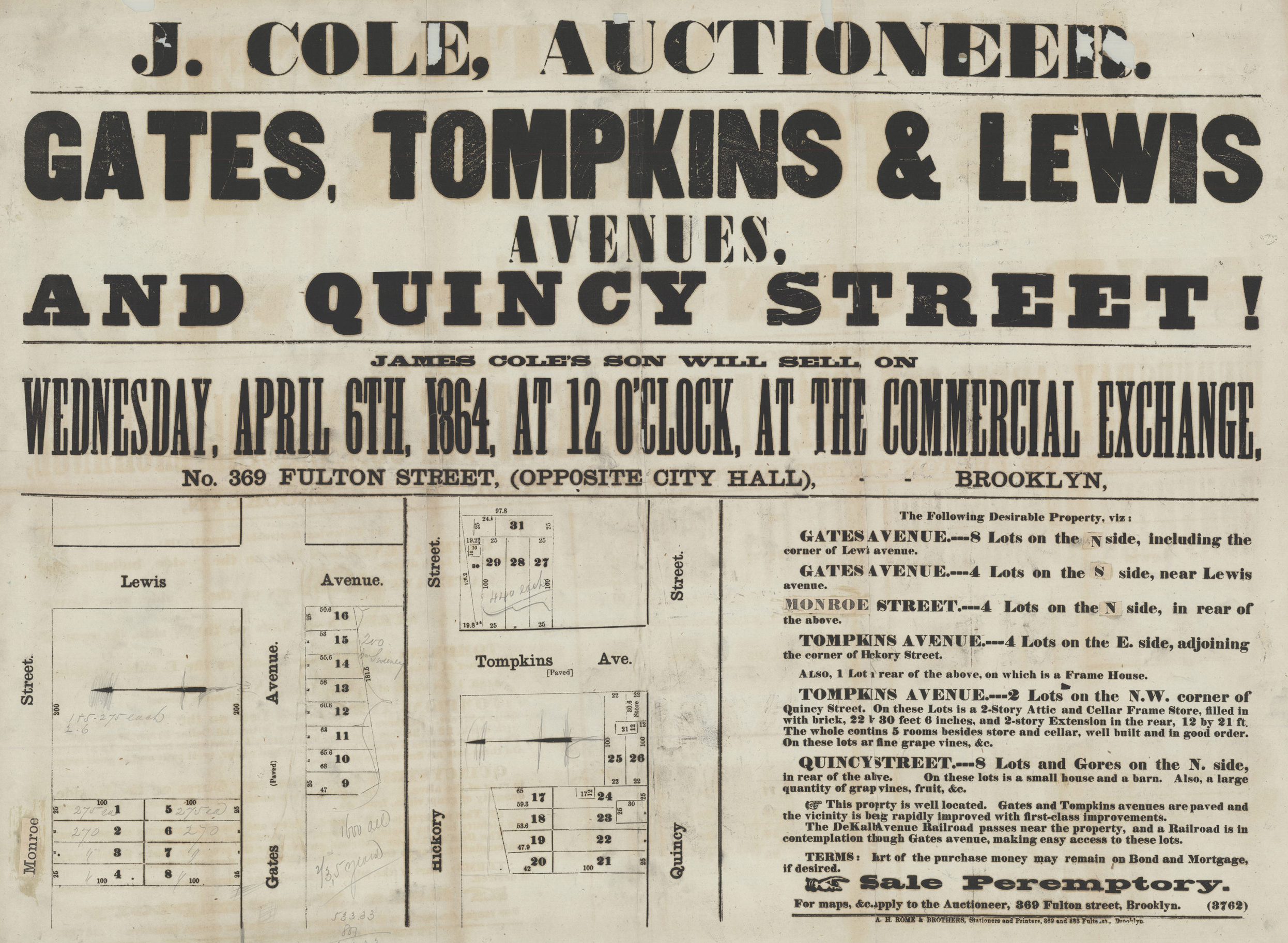
More than two years in the making, their new map portal holds more than 1,500 maps stretching from the 18th to the 21st century. Users can search by keyword or narrow maps down by neighborhood, subject and date. A quick dive into the resources uncovered a hand-drawn and delicately colored 1797 survey of Bushwick, 19th century atlas pages for East New York and a 1922 auction booklet for property in Bay Ridge.
“The launch of the map portal is a huge moment for the accessibility of our collections,” Maggie Schreiner, Manager of Archives and Special Collections, told Brownstoner. “Maps pose unique access issues, primarily due to their size and fragility, which means that we try to minimize handling to preserve the materials in the long term. The map portal allows us to make all our maps accessible to users regardless of their location.”
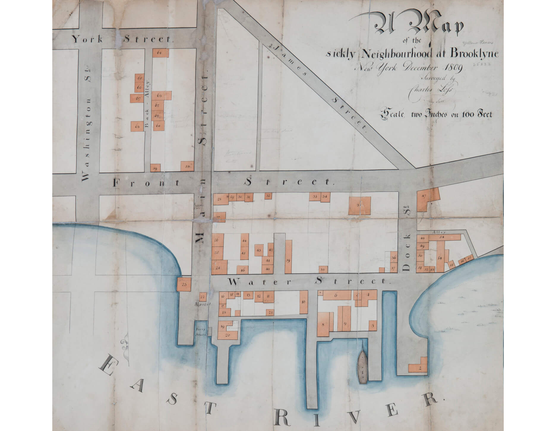
That fragility meant that some maps have been largely unavailable to researchers until now. Paper conservators had to address condition issues on 10 maps before they could be digitized. One of those, perhaps particularly poignant now, is the “Map of the sickly Neighbourhood of Brooklyne” from 1809. Produced during a yellow fever epidemic, the map of present-day Dumbo is accompanied by notes documenting the use and residents of the buildings in an attempt to create a tally of victims of the deadly disease.
While the project was nearing completion before the current pandemic hit, its launch at time when access to so many historic sites remains restricted is particularly meaningful. The majority of the BHS map collection is now available for searching, although about 20 more maps are still to be uploaded.
For those looking to dig into the resource, the maps aren’t confined to Brooklyn and Long Island. The other boroughs are represented as well as locations outside of the city and state. They also vary in type — there are hand-drawn maps, bird’s-eye views, mass-produced maps, site plans — and we spotted at least one floor plan.
The map project is just the latest update to the organization’s online research and collections portal. Last year film, video and audio recordings were digitized. New items and information are also regularly added to the database of art and artifacts.
Related Stories
- Distract Yourself With These Research Resources You Can Use from Home
- Binge Watch Brooklyn’s Past With Brooklyn Historical Society’s New Online Video Resource
- See What Your Home Once Looked Like With Newly Digitized 1940s Tax Photos
Sign up for amNY’s COVID-19 newsletter to stay up to date on the latest coronavirus news throughout New York City. Email tips@brownstoner.com with further comments, questions or tips. Follow Brownstoner on Twitter and Instagram, and like us on Facebook.


What's Your Take? Leave a Comment