
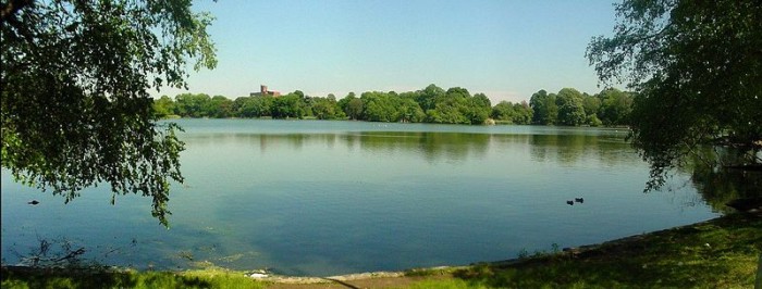
Past and Present: The Lake in Prospect Park
We continue this week’s look at Brooklyn’s natural treasure: Prospect Park. A look at Brooklyn, then and now. Because it was so carefully planned and executed almost 150 years ago, Prospect Park today looks as if it has always been there. Which, of course, was the whole idea. If you don’t know the park’s history,…
Prospect Park Lake. Photo: Gary Osgood for Wiki Commons

We continue this week’s look at Brooklyn’s natural treasure: Prospect Park.
A look at Brooklyn, then and now.
Because it was so carefully planned and executed almost 150 years ago, Prospect Park today looks as if it has always been there. Which, of course, was the whole idea.
If you don’t know the park’s history, you could easily think that all the landscapers needed to do was to enclose the park with a fence, cut some roads and pathways, build a couple of bridges and a grand entrance or three, and mow the lawn.
But in reality, Prospect Park is as constructed as the sets of Lord of the Rings in New Zealand. Every aspect of both the park and the Shire was carefully thought out and crafted.
After Calvert Vaux and Frederick Law Olmsted finished Central Park in 1857, Brooklyn wanted a grand park too. The two cities were fierce rivals, while also co-dependent. Brooklyn’s city fathers came up with a park committee whose president was one of Brooklyn’s leading citizens, James S.T. Stranahan.
The committee gave the job of designing the park to Egbert L. Viele, the Charlie Brown of landscape engineering. He had been chief engineer of the Central Park project until Olmsted and Vaux came up with a better design and replaced him.
The general area for the park had already been decided on. The terminal moraine left by the great Wisconsonian glacier that had ripped through Long Island thousands of years before had created several high spots that proved to be important historical places as well as topographical monuments.
They were Mount Prospect, upon which now sat Brooklyn’s city reservoir, and Battle Pass, one of the sites of the 1776 Battle of Brooklyn, the earliest and bloodiest battle of the Revolutionary War. Mount Prospect had been a lookout fortification for the Colonial forces.
In between these two points were dozens of acres of land. Much of it was marsh and swamp, a malodorous place that people were certain oozed disease and death. There was also a lot of rocky ground, used-up farmland, and a small number of working farms and homesteads scattered in between.
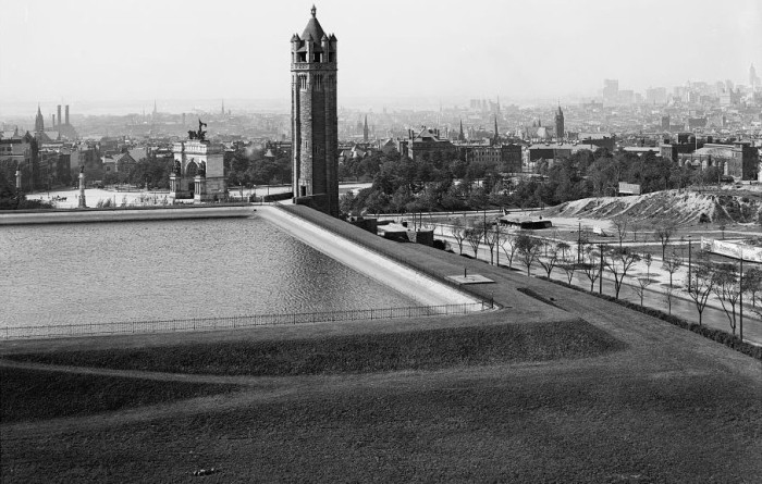
Mount Prospect Reservoir via Museum of the City of New York
The park plan that Viele devised would include Mount Prospect and the reservoir, and stretch over to Battle Pass and beyond. Running through the middle of the new park would be Flatbush Avenue, which even back in the Revolutionary War days had been a major thoroughfare.
Viele’s plan took advantage of the natural features of the existing terrain. He wanted a parade ground, some flower gardens, and, of course, he already had the reservoir and the hills. He thought that his park “required but little aid from art to fit it for all the purposes of health and recreation.”
The city went ahead and bought the land needed for the park, from Prospect Heights to the middle of Park Slope, neither of which were very well established neighborhoods yet.
Unfortunately, the year was now 1861, and Brooklyn and the rest of the Union were about to head into the Civil War. All plans for a grand park were tabled indefinitely.
While the war raged on, Stranahan and his committee began to have second thoughts about Viele’s plan. They had a few meetings and decided that when the war was over, they were going to get a second opinion.
In 1865, Stranahan invited Calvert Vaux to take a walk with him on the proposed park site. He wanted the landscape architect’s opinion. At this point, Frederick Law Olmsted was still living in California.
Vaux was not impressed. He didn’t like the reservoir, and he really hated Flatbush Avenue bisecting the park with its heavy traffic. He prepared a report for Stranahan with some suggestions. He told him the city should forget the eastern end of the park with the reservoir, and sell the land they had acquired over there.
He wanted them to put the entire park west of Flatbush Avenue, and he wanted the city to buy much more land to the west and south.
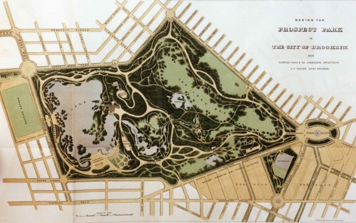
Olmsted & Vaux’s 1871 map via Prospect Park Alliance
Vaux sent a letter to Olmsted in California, telling him about the project. Over the course of that year, they prepared a detailed plan, which they submitted to Stranahan’s committee in 1866. It outlined and illustrated their idea for a three-fold park, basically consisting of meadows, woods and a lake district.
The committee was impressed. Vaux wrote to Olmsted to tell him it was time to put the band back together. Olmsted headed east, and the two men replaced poor Egbert Viele for the second time.
Stranahan and the committee had to undo a lot of work, and spend a lot of new money. The city had purchased a great deal of land through eminent domain, and was now being asked to sell half of it and buy a whole lot more.
Most of this new land belonged to Edwin Litchfield, the railroad and real estate magnate whose villa would be swallowed by the revised parkland. He was a canny real estate player, and he took the city for every dime he could get, and tossed his own house into the mix as well.
Olmsted and Vaux’s Prospect Park had better be good. There was a lot riding on it.
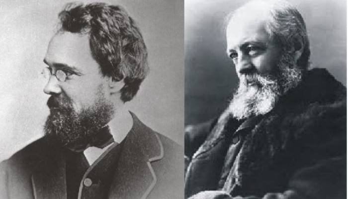
Calvert Vaux and Frederick Law Olmsted via Olmsted.org
The city had to apply to the state legislature for funding to buy the new land, and that took years. Meanwhile, Olmsted and Vaux concentrated on the new entrance to the park at Grand Army Plaza, as well as the landscaping on the western part of the park that the city already owned.
There were occasional hills, courtesy of the glacier, which also dug deep gullies and deposited large rocks. Most of the land however, was a flat plane upon which were small farms and a lot of scrub land. Several old roads had been cut through the acreage, and old gravel and clay pits sat like open sores on the landscape.
This 1866 photograph shows much of the land that was going to be part of the new artificial watercourse that would lead to a large lake.
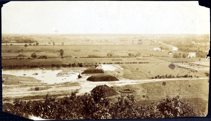
1866 photograph via Museum of the City of New York
Olmsted and Vaux first had a detailed topographical survey made by David O. Frost. This gave them a blueprint for the foundations of the park – the work that had to be done before the planting of foliage and trees.
First thing, the water needed to be controlled and swamps drained through a vast underground drainage system. The old farms and houses had to go, and the old roads covered over. Then the system of new roads, bridle paths and walkways needed to be laid out and graded. This was dictated by the natural topography as well as plans the men had to create the ideal “natural” park.
The biggest project would be digging the water system and the lakes. That alone would take four years. The waterways needed to be connected to a well, reservoir and waterworks that would ensure that the lakes and streams were always full of fresh water.
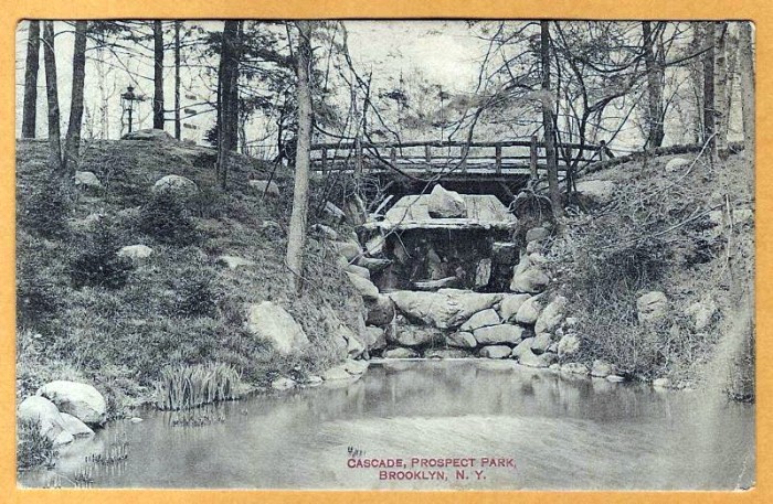
The Cascade in Prospect Park, postcard
The water system began at the Swan Boat Lake at the end of the Long Meadow. This was originally called The Pools. A stream called the Ambergill meandered from the Swan Boat Lake through a deep rocky ravine, an original feature left by the glacier, until it came out through the Midwood and into the Nethermead.
From there, the water course passes through the Binnen Water Pool and the Lily Pond Lake, and empties over a waterfall into the Lullwater. That body of water serenely winds its way to the 57 acre lake, one of the most impressive parts of the park.
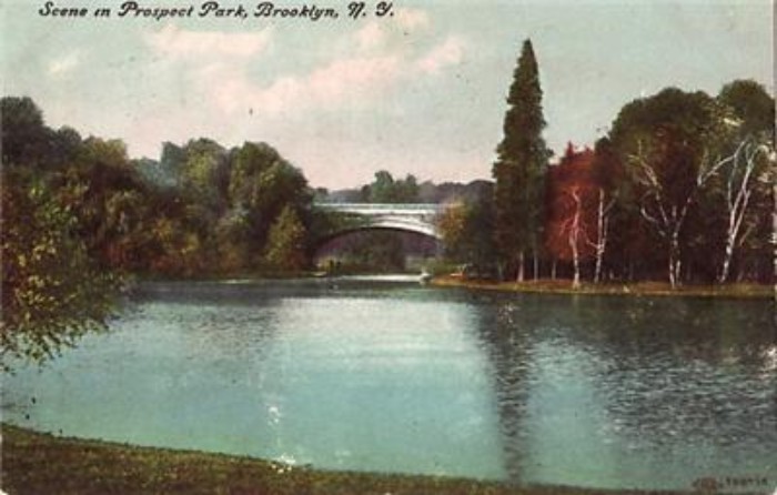
1909 postcard
They used early earth-moving machines, which greatly helped with digging out the lake, but most of the work was dug the old fashioned way — by hand, one shovelful of dirt at a time. It was a Herculean task, and no wonder it took four years.
But when they were done – whoa. The eastern portion of the park was opened to public in 1867, and was well received. Work on the western portion continued until the Panic of 1873, a serious financial depression. That halted construction for several years.
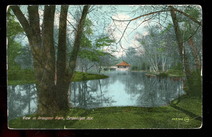
1916 postcard
It wouldn’t be until 1885 that the second phase of the park was completed. The classical components of the park — the grand entrances and buildings of McKim, Mead & White — all came much later, and were never part of Olmsted & Vaux’s original design.
Prospect Park was so successful it became a model for other cities to follow. What’s that saying about imitation being the most sincere form of flattery? That’s a great compliment for a great park.
Gary Osgood for Wikimedia Commons


it’s no exaggeration when i say that the prospect park lake might be my favorite place in the city. <3 what a masterpiece